
Scattered thunderstorms will develop across the northern half of central Indiana by late this afternoon, shifting south this evening.
A few storms may produce damaging winds and large hail.
Localized flooding from heavy rainfall will also be possible.
INDIANAPOLIS 7-DAY EXTENDED FORECAST
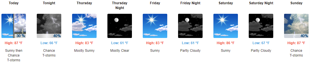
Today: A 30 percent chance of showers and thunderstorms, mainly after 3pm. Mostly sunny, with a high near 87. West wind 6 to 9 mph.
Tonight: A 40 percent chance of showers and thunderstorms. Mostly cloudy, with a low around 66. Northwest wind around 6 mph becoming light and variable in the evening.
Thursday: Mostly sunny, with a high near 83. North northeast wind 3 to 6 mph.
Thursday Night: Mostly clear, with a low around 61. North northeast wind 3 to 6 mph.
Friday: Sunny, with a high near 83. East wind 3 to 6 mph.
Friday Night: Partly cloudy, with a low around 61. East wind around 6 mph becoming calm in the evening.
Saturday: Sunny, with a high near 86. Light southeast wind.
Saturday Night: Partly cloudy, with a low around 67. Light southeast wind.
Sunday: A 40 percent chance of showers and thunderstorms, mainly after 2pm. Partly sunny, with a high near 87. Calm wind becoming south southwest around 6 mph in the afternoon.
Sunday Night: A 30 percent chance of showers and thunderstorms, mainly after 2am. Mostly cloudy, with a low around 71. South southwest wind 3 to 6 mph.
Monday: Showers and thunderstorms likely. Partly sunny, with a high near 88. Chance of precipitation is 60%.
Monday Night: Showers and thunderstorms likely. Mostly cloudy, with a low around 73. Chance of precipitation is 60%.
Tuesday: A 50 percent chance of showers and thunderstorms. Mostly sunny, with a high near 90.
SOURCE: NWS Indianapolis.
Follow NWS Indianapolis on Twitter @NWSIndianapolis for the latest Indianapolis area weather news.