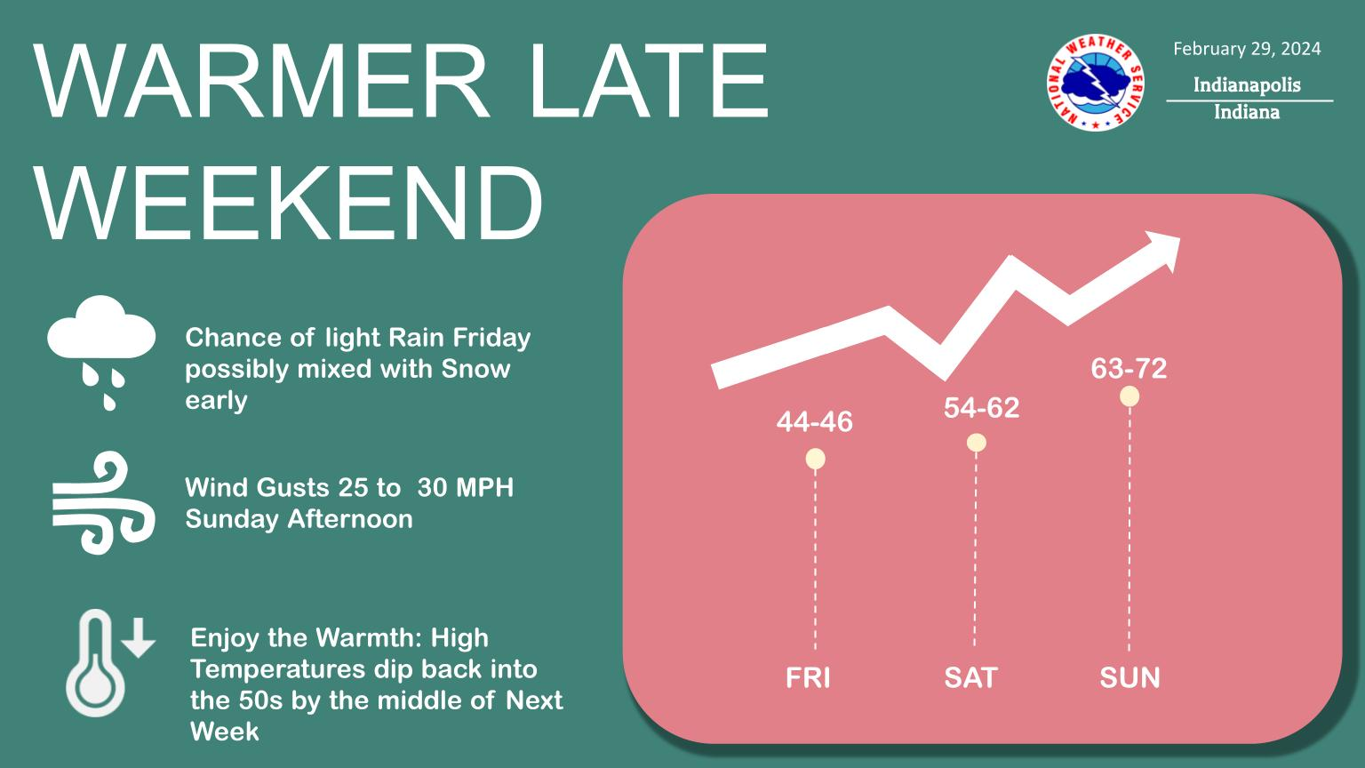
Warmer temperatures and dry weather will return late this weekend.
Temperatures will climb all the way back to the 60s and maybe even lower 70s by Sunday!
NEXT 12 HOURS

NEXT 12-24 HOURS

INDIANAPOLIS DAILY CLIMATE DATA

INDIANAPOLIS 7-DAY EXTENDED FORECAST

Today: Sunny, with a high near 46. Calm wind becoming southwest around 6 mph in the afternoon.
Tonight: Mostly clear, with a low around 29. South southeast wind 6 to 9 mph.
Friday: A slight chance of snow showers before 9am, then a chance of rain showers. Increasing clouds, with a high near 46. South wind 7 to 9 mph. Chance of precipitation is 50%. New precipitation amounts of less than a tenth of an inch possible.
Friday Night: Mostly cloudy, with a low around 40. South southeast wind 6 to 8 mph.
Saturday: Partly sunny, with a high near 59. South wind 6 to 8 mph.
Saturday Night: Mostly clear, with a low around 45. South southeast wind 9 to 14 mph, with gusts as high as 20 mph.
Sunday: Mostly sunny, with a high near 69. South wind 13 to 17 mph, with gusts as high as 25 mph.
Sunday Night: Partly cloudy, with a low around 53. South wind 14 to 16 mph, with gusts as high as 24 mph.
Monday: A 30 percent chance of showers, mainly after 1pm. Mostly sunny, with a high near 71. South wind 14 to 16 mph, with gusts as high as 24 mph.
Monday Night: Showers likely. Mostly cloudy, with a low around 47. South wind around 15 mph, with gusts as high as 22 mph. Chance of precipitation is 60%.
Tuesday: A 40 percent chance of showers. Partly sunny, with a high near 58.
Tuesday Night: A 40 percent chance of showers. Mostly cloudy, with a low around 45.
Wednesday: A 40 percent chance of showers. Partly sunny, with a high near 57.
THE UNITED STATES OF AMERICA 3-DAY OUTLOOK


SOURCE: NWS Indianapolis.
Follow NWS Indianapolis on Twitter @NWSIndianapolis for the latest Indianapolis area weather news.