
Several well above normal days are in the current forecast over the next week, with potentially near record warmth in a few locations across Central Indiana.
A cold front will bring a brief return to seasonal temperatures Wednesday & Thursday, but then temperatures warm again as we march into March.
The main concern in the near future resides with severe weather potential Tuesday, mainly Tuesday evening.
POSSIBLE SEVER WEATHER TUESDAY
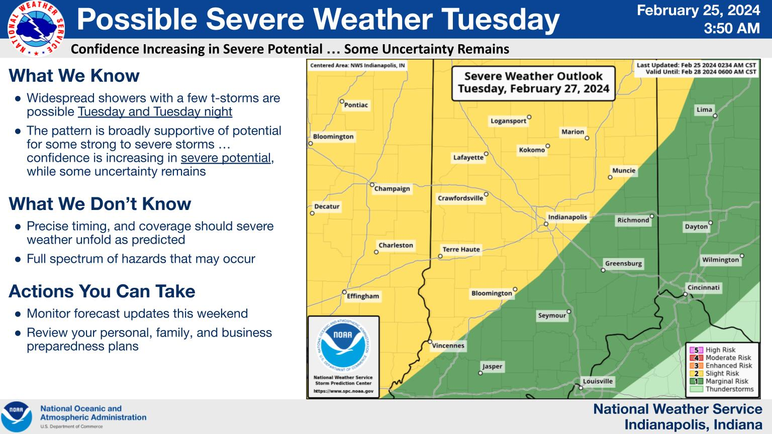
The potential for severe thunderstorms Tuesday and Tuesday night remains.
While confidence is increasing in this potential, some uncertainty remains regarding timing, location and coverage.
Please monitor forecast updates through the next few days and take time to review your preparedness plans.
NEXT 12 HOURS

NEXT 12-24 HOURS

INDIANAPOLIS DAILY CLIMATE DATA

INDIANAPOLIS 7-DAY EXTENDED FORECAST

Today: Mostly sunny, with a high near 57. South southwest wind around 16 mph, with gusts as high as 24 mph.
Tonight: Mostly clear, with a low around 38. South wind 5 to 9 mph.
Monday: Sunny, with a high near 68. East southeast wind 5 to 10 mph becoming south southwest in the afternoon.
Monday Night: A 20 percent chance of showers after 1am. Mostly cloudy, with a low around 55. South wind 9 to 14 mph, with gusts as high as 23 mph.
Tuesday: A chance of rain before 10am, then a chance of rain and thunderstorms between 10am and 1pm, then rain likely and possibly a thunderstorm after 1pm. Mostly cloudy, with a high near 68. South wind 13 to 18 mph, with gusts as high as 29 mph. Chance of precipitation is 60%. New rainfall amounts of less than a tenth of an inch, except higher amounts possible in thunderstorms.
Tuesday Night: Rain and possibly a thunderstorm. Low around 56. Breezy, with a south southwest wind 22 to 28 mph, with gusts as high as 41 mph. Chance of precipitation is 80%. New rainfall amounts between a quarter and half of an inch possible.
Wednesday: Rain likely and possibly a thunderstorm before 1pm, then a chance of rain and thunderstorms after 1pm. Mostly cloudy, with a high near 59. Breezy, with a southwest wind around 22 mph becoming west northwest in the afternoon. Winds could gust as high as 37 mph. Chance of precipitation is 60%.
Wednesday Night: A slight chance of rain and snow showers before 1am. Partly cloudy, with a low around 23. Blustery, with a northwest wind 17 to 22 mph decreasing to 11 to 16 mph after midnight. Winds could gust as high as 32 mph. Chance of precipitation is 20%.
Thursday: Sunny, with a high near 40. Northwest wind 8 to 10 mph.
Thursday Night: Mostly clear, with a low around 28. South southeast wind around 9 mph.
Friday: Sunny, with a high near 52.
Friday Night: Mostly clear, with a low around 37.
Saturday: Mostly sunny, with a high near 60.
THE UNITED STATES OF AMERICA 3-DAY OUTLOOK


SOURCE: NWS Indianapolis.
Follow NWS Indianapolis on Twitter @NWSIndianapolis for the latest Indianapolis area weather news.