
Expect Sunshine and warm temperatures today and again on Wednesday. Highs today will reach the low to middle 50s.
Rain is expected on Wednesday Night and Thursday. There will be about a 20% chance for a Thunderstorm.
NEXT 12-24 HOURS
INDIANAPOLIS DAILY CLIMATE DATA
INDIANAPOLIS 7-DAY EXTENDED FORECAST

Today: Sunny, with a high near 56. South wind 3 to 6 mph.
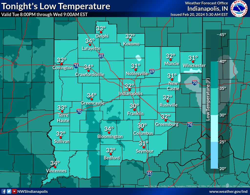
Tonight: Mostly clear, with a low around 32. South wind 5 to 7 mph.
Wednesday: Mostly sunny, with a high near 61. South wind 8 to 14 mph, with gusts as high as 23 mph.
Wednesday Night: A chance of showers between 1am and 4am, then a chance of showers and thunderstorms after 4am. Cloudy, with a low around 52. South wind 10 to 13 mph, with gusts as high as 18 mph. Chance of precipitation is 40%.
Thursday: Showers and possibly a thunderstorm. High near 56. South wind around 11 mph becoming west in the afternoon. Winds could gust as high as 18 mph. Chance of precipitation is 90%. New rainfall amounts between a half and three quarters of an inch possible.
Thursday Night: A 30 percent chance of showers before 1am. Mostly cloudy, with a low around 36. Northwest wind 11 to 16 mph, with gusts as high as 25 mph.
Friday: Sunny, with a high near 47. West northwest wind 14 to 16 mph, with gusts as high as 24 mph.
Friday Night: Partly cloudy, with a low around 30. North northwest wind 9 to 14 mph, with gusts as high as 21 mph.
Saturday: Sunny, with a high near 44. North northwest wind 9 to 13 mph, with gusts as high as 18 mph.
Saturday Night: Mostly clear, with a low around 34. South southwest wind 11 to 14 mph, with gusts as high as 20 mph.
Sunday: Mostly sunny, with a high near 59. Breezy.
Sunday Night: A 20 percent chance of showers. Partly cloudy, with a low around 42.
Monday: A 20 percent chance of showers. Sunny, with a high near 63.
THE UNITED STATES OF AMERICA 3-DAY OUTLOOK


SOURCE: NWS Indianapolis.
Follow NWS Indianapolis on Twitter @NWSIndianapolis for the latest Indianapolis area weather news.