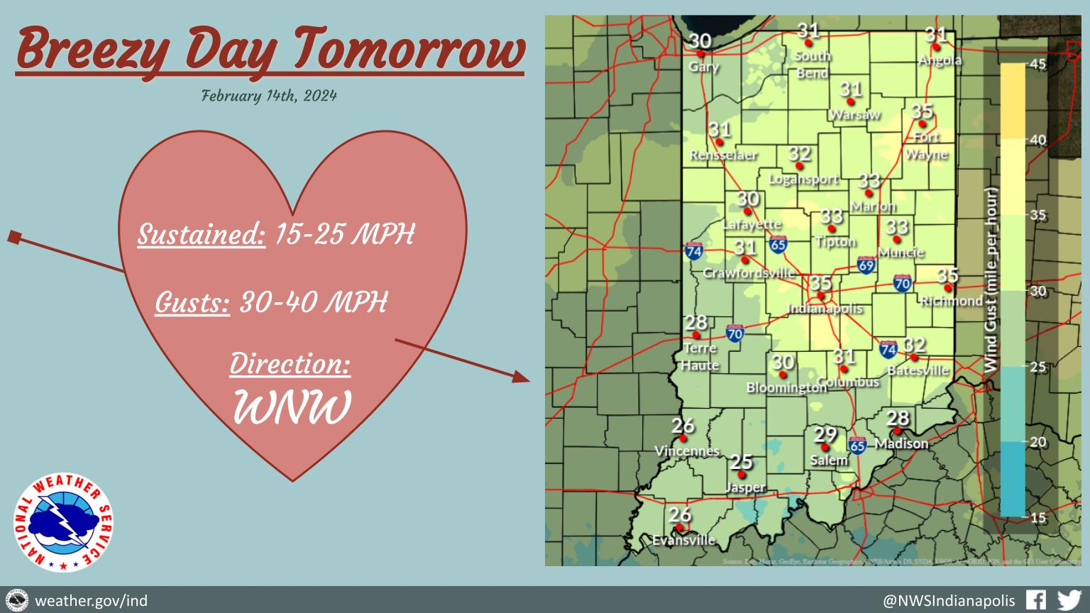
Following a mild and calm Valentine’s Day, winds will increase tomorrow.
Expect sustained winds out of the WNW around 20 MPH with consistent gusts around 35MPH.
NEXT 12 HOURS
NEXT 12-24 HOURS
INDIANAPOLIS DAILY CLIMATE DATA

INDIANAPOLIS 7-DAY EXTENDED FORECAST

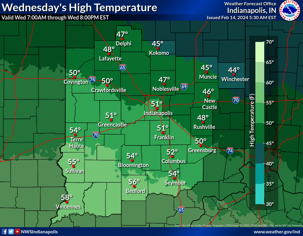
Today: Sunny, with a high near 51. East wind around 5 mph becoming calm in the afternoon.
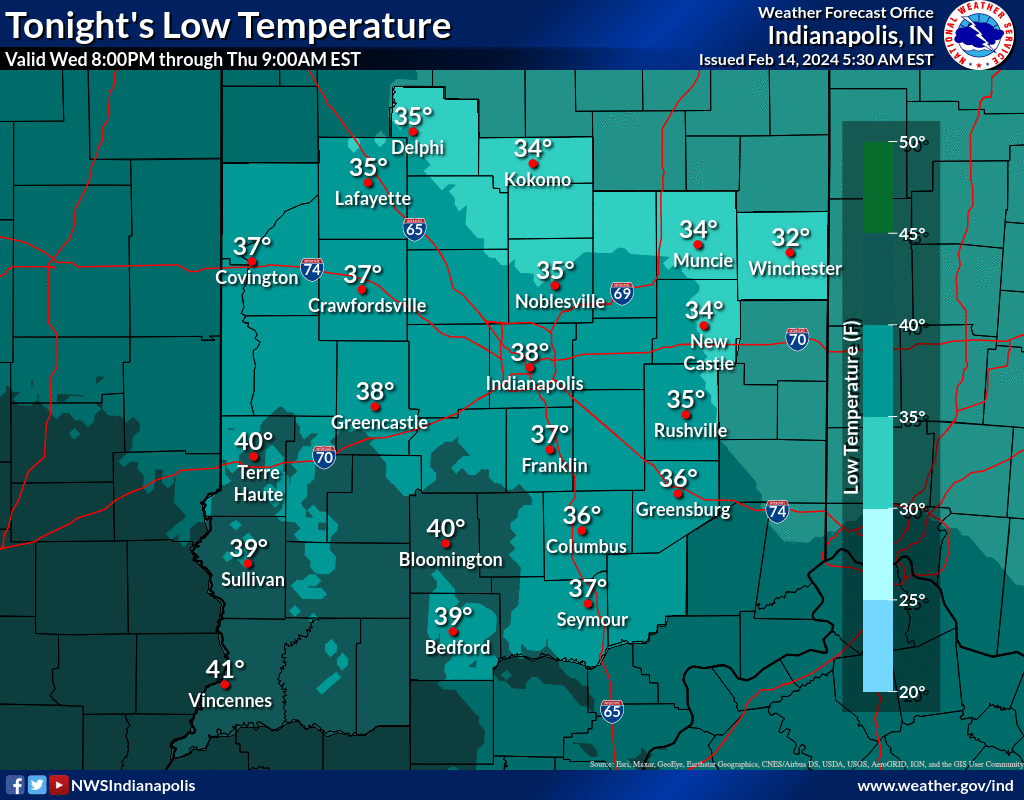
Tonight: Increasing clouds, with a low around 38. East southeast wind 6 to 10 mph becoming south after midnight.
Thursday: Scattered showers before 1pm. Partly sunny, with a high near 52. Breezy, with a south southwest wind 15 to 22 mph becoming west northwest in the afternoon. Winds could gust as high as 34 mph. Chance of precipitation is 40%.
Thursday Night: Increasing clouds, with a low around 29. Northwest wind 8 to 11 mph, with gusts as high as 18 mph.
Friday: A 50 percent chance of snow showers after 1pm. Mostly cloudy, with a high near 37. North northeast wind 6 to 9 mph.
Friday Night: A 30 percent chance of snow showers before 1am. Mostly cloudy, with a low around 22. Northwest wind 10 to 14 mph, with gusts as high as 21 mph.
Saturday: Mostly sunny, with a high near 30. West wind 14 to 17 mph, with gusts as high as 24 mph.
Saturday Night: Mostly clear, with a low around 23. West southwest wind 13 to 15 mph, with gusts as high as 23 mph.
Sunday: Sunny, with a high near 42. West southwest wind around 18 mph, with gusts as high as 28 mph.
Sunday Night: Mostly clear, with a low around 26. West southwest wind 9 to 14 mph, with gusts as high as 21 mph.
Washington’s Birthday: Mostly sunny, with a high near 46.
Monday Night: A 20 percent chance of showers. Mostly cloudy, with a low around 33.
Tuesday: Partly sunny, with a high near 51.
THE UNITED STATES OF AMERICA 3-DAY OUTLOOK


SOURCE: NWS Indianapolis.
Follow NWS Indianapolis on Twitter @NWSIndianapolis for the latest Indianapolis area weather news.