
Dense fog will continue to cause travel impacts through this morning with the visibility frequently around a quarter mile.
Coverage and persistence may again be higher central and north, but all of central Indiana will be impacted.

The visibility will be around a quarter mile at times this morning.
Slow down and allow extra time for the morning commute!
Rain will move in this afternoon and evening.

Ice jam flooding will be possible this week.
People with interests around area rivers, particularly Wildcat Creek, upper portions of the Wabash and the Tippecanoe and nearby streams should note to changes in ice or river levels.
NEXT 12-24 HOURS

INDIANAPOLIS DAILY CLIMATE DATA

INDIANAPOLIS 7-DAY EXTENDED FORECAST
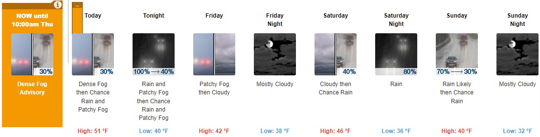
Today: A 30 percent chance of rain after 3pm. Widespread dense fog, mainly before noon. Otherwise, cloudy, with a high near 51. Light east wind.
Tonight: Rain, mainly before 1am. Patchy fog. Low around 40. East wind 6 to 9 mph becoming west after midnight. Winds could gust as high as 20 mph. Chance of precipitation is 100%. New precipitation amounts between a quarter and half of an inch possible.
Friday: Patchy fog before 8am. Otherwise, cloudy, with a steady temperature around 42. West wind 9 to 11 mph.
Friday Night: Mostly cloudy, with a low around 38. West wind 5 to 7 mph becoming northeast after midnight.
Saturday: A 40 percent chance of rain after 2pm. Cloudy, with a high near 46. Northeast wind 5 to 10 mph.
Saturday Night: Rain, mainly after 8pm. Low around 36. North northeast wind 11 to 18 mph, with gusts as high as 28 mph. Chance of precipitation is 80%. New precipitation amounts between a quarter and half of an inch possible.
Sunday: Rain likely, mainly before 8am. Cloudy, with a high near 40. North wind around 18 mph, with gusts as high as 28 mph. Chance of precipitation is 70%.
Sunday Night: Mostly cloudy, with a low around 32. North northwest wind 10 to 16 mph, with gusts as high as 23 mph.
Monday: Mostly cloudy, with a high near 39. Northwest wind around 10 mph.
Monday Night: Mostly cloudy, with a low around 31. Southwest wind around 9 mph.
Tuesday: Mostly cloudy, with a high near 43.
Tuesday Night: Mostly cloudy, with a low around 32.
Wednesday: Partly sunny, with a high near 48.
THE UNITED STATES OF AMERICA 3-DAY OUTLOOK


SOURCE: NWS Indianapolis.
Follow NWS Indianapolis on Twitter @NWSIndianapolis for the latest Indianapolis area weather news.