
Look for dry and seasonable conditions through Friday, with highs in the 30s to around 40 and lows in the 20s.
A system will bring a rain and snow mix on Saturday, with a low potential for snow accumulation.
NEW YEAR RECORDS
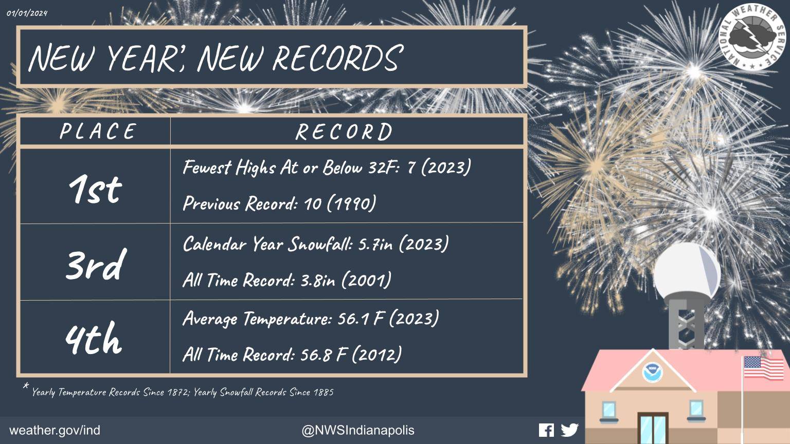
Happy New Year! With the new year comes new records at the conclusion of 2023.
This includes, the 4th warmest year (average temperature), and 3rd least snowiest calendar year.
NEXT 12-24 HOURS

INDIANAPOLIS DAILY CLIMATE DATA
INDIANAPOLIS 7-DAY EXTENDED FORECAST

Today: Partly sunny, with a high near 40. Southwest wind 10 to 14 mph, with gusts as high as 22 mph.
Tonight: Mostly cloudy, with a low around 28. Southwest wind 8 to 11 mph.
Wednesday: Partly sunny, with a high near 39. Southwest wind 6 to 8 mph.
Wednesday Night: Mostly cloudy, with a low around 27. North northwest wind 8 to 10 mph.
Thursday: Sunny, with a high near 37. North wind 7 to 10 mph.
Thursday Night: Partly cloudy, with a low around 23. North northeast wind around 6 mph becoming southeast after midnight.
Friday: Partly sunny, with a high near 39. South southeast wind 6 to 8 mph.
Friday Night: A 30 percent chance of snow after 1am. Mostly cloudy, with a low around 30. East southeast wind around 7 mph.
Saturday: Snow likely before 1pm, then a chance of rain and snow. Mostly cloudy, with a high near 39. East wind 7 to 11 mph. Chance of precipitation is 60%.
Saturday Night: A 40 percent chance of snow, mainly before 1am. Mostly cloudy, with a low around 29. North wind 9 to 11 mph becoming west northwest after midnight.
Sunday: A slight chance of rain and snow. Partly sunny, with a high near 40. Chance of precipitation is 20%.
Sunday Night: Mostly cloudy, with a low around 29.
Monday: Mostly cloudy, with a high near 44.
THE UNITED STATES OF AMERICA 3-DAY OUTLOOK


SOURCE: NWS Indianapolis.
Follow NWS Indianapolis on Twitter @NWSIndianapolis for the latest Indianapolis area weather news.