
Take advantage of the decent weather today before rain, winds, snow, and frigid temperatures arrive in central Indiana.
Rain will start to move in late tonight from the west and last through the day Friday.
Snow will mix in Friday evening, becoming all snow by midnight.
Strong winds are also expected Friday that will lead to blowing snow.
Much colder temperatures arrive this weekend.
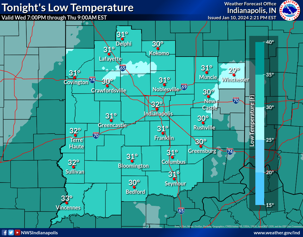
NEXT 12-24 HOURS
INDIANAPOLIS DAILY CLIMATE DATA

INDIANAPOLIS 7-DAY EXTENDED FORECAST

Today: Mostly cloudy, with a steady temperature around 37. West wind 11 to 16 mph, with gusts as high as 24 mph.
Tonight: Rain likely, mainly after 5am. Increasing clouds, with a low around 34. Southwest wind 5 to 14 mph becoming east after midnight. Winds could gust as high as 20 mph. Chance of precipitation is 60%. New precipitation amounts of less than a tenth of an inch possible.
Friday: Rain. High near 46. Breezy, with a southeast wind 22 to 25 mph, with gusts as high as 38 mph. Chance of precipitation is 100%. New precipitation amounts between 1 and 2 inches possible.
Friday Night: Rain before 8pm, then rain and snow between 8pm and 11pm, then snow after 11pm. Patchy blowing snow between 11pm and 2am. Low around 22. Windy, with a west southwest wind 29 to 34 mph, with gusts as high as 55 mph. Chance of precipitation is 100%. New precipitation amounts between a tenth and quarter of an inch possible.
Saturday: A 50 percent chance of snow, mainly before 8am. Cloudy, with a high near 26. Breezy, with a west southwest wind 22 to 28 mph, with gusts as high as 43 mph.
Saturday Night: A 20 percent chance of snow. Mostly cloudy, with a low around 8. Breezy, with a west wind around 21 mph, with gusts as high as 32 mph.
Sunday: A slight chance of snow before 8am, then a slight chance of snow after 2pm. Mostly cloudy, with a high near 15. West wind 16 to 18 mph, with gusts as high as 29 mph. Chance of precipitation is 20%.
Sunday Night: A 30 percent chance of snow, mainly between 8pm and 2am. Mostly cloudy, with a low around 2. West northwest wind 10 to 15 mph, with gusts as high as 21 mph.
M.L.King Day: A 20 percent chance of snow before 8am. Mostly cloudy and cold, with a high near 12. West northwest wind around 11 mph.
Monday Night: A 20 percent chance of snow after 8pm. Mostly cloudy, with a low around 3. West northwest wind around 10 mph.
Tuesday: A 20 percent chance of snow. Partly sunny and cold, with a high near 12.
Tuesday Night: A 20 percent chance of snow. Partly cloudy, with a low around 6.
Wednesday: Mostly sunny, with a high near 24.
THE UNITED STATES OF AMERICA 3-DAY OUTLOOK


SOURCE: NWS Indianapolis.
Follow NWS Indianapolis on Twitter @NWSIndianapolis for the latest Indianapolis area weather news.