
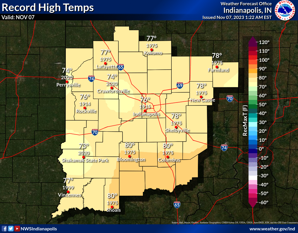
Another unseasonably warm day is in the forecast for Central Indiana with highs ranging from the mid 60s in the north to the mid 70s further south!
INDIANAPOLIS DAILY CLIMATE DATA
INDIANAPOLIS 7-DAY EXTENDED FORECAST
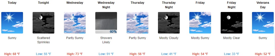
Today: Sunny, with a high near 68. West wind around 6 mph becoming north in the afternoon.
Tonight: Scattered sprinkles after 10pm. Increasing clouds, with a low around 55. Northeast wind 7 to 9 mph becoming east southeast after midnight.
Wednesday: Partly sunny, with a high near 73. South southwest wind 10 to 16 mph, with gusts as high as 24 mph.
Wednesday Night: Showers likely, mainly before 1am. Mostly cloudy, with a low around 51. South southwest wind 14 to 18 mph becoming west northwest after midnight. Winds could gust as high as 28 mph. Chance of precipitation is 60%. New precipitation amounts of less than a tenth of an inch possible.
Thursday: Partly sunny, with a high near 56. Northwest wind 10 to 14 mph, with gusts as high as 20 mph.
Thursday Night: Mostly cloudy, with a low around 41. West northwest wind 7 to 9 mph.
Friday: Mostly sunny, with a high near 54. West northwest wind 7 to 10 mph.
Friday Night: Mostly clear, with a low around 33. West northwest wind 6 to 9 mph.
Veterans Day: Sunny, with a high near 52. North northeast wind 6 to 9 mph.
Saturday Night: Mostly clear, with a low around 33. East wind around 8 mph.
Sunday: Mostly sunny, with a high near 54.
Sunday Night: Mostly clear, with a low around 35.
Monday: Sunny, with a high near 56.
THE UNITED STATES OF AMERICA 3-DAY OUTLOOK

SOURCE: NWS Indianapolis.
Follow NWS Indianapolis on Twitter @NWSIndianapolis for the latest Indianapolis area weather news.