
Expect partly cloudy skies today with highs in the 80s for one more day.
A cold front will bring rain and cooler temperatures to Central Indiana on Thursday.
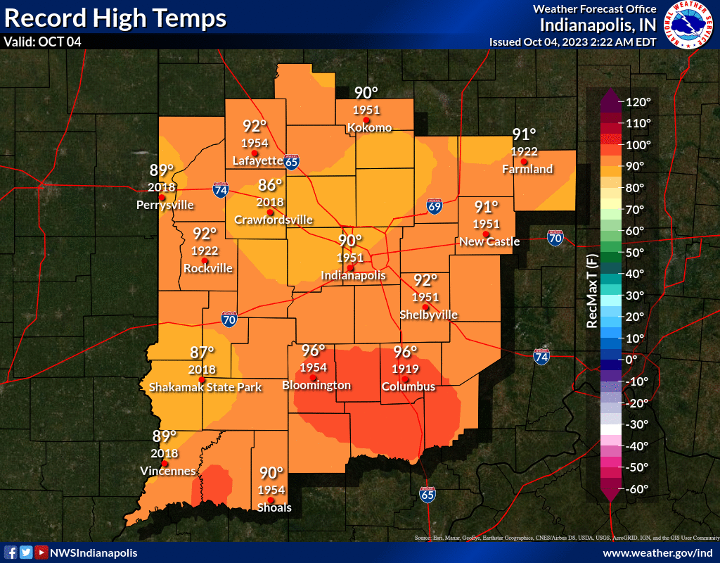
INDIANAPOLIS DAILY CLIMATE DATA
INDIANAPOLIS 7-DAY EXTENDED FORECAST

Today: Partly sunny, with a high near 86. South southwest wind around 11 mph, with gusts as high as 18 mph.
Tonight: Isolated showers after 5am. Mostly cloudy, with a low around 64. South wind 6 to 8 mph. Chance of precipitation is 10%.
Thursday: Showers, with thunderstorms also possible after 5pm. Steady temperature around 67. South southwest wind 9 to 11 mph, with gusts as high as 20 mph. Chance of precipitation is 100%. New rainfall amounts between a quarter and half of an inch possible.
Thursday Night: Showers and possibly a thunderstorm before 11pm, then showers likely. Low around 58. South southwest wind 9 to 13 mph, with gusts as high as 20 mph. Chance of precipitation is 80%. New precipitation amounts between a quarter and half of an inch possible.
Friday: Scattered showers, mainly before 8am. Mostly sunny, with a high near 67. West northwest wind 7 to 11 mph. Chance of precipitation is 30%.
Friday Night: Scattered showers after 8pm. Partly cloudy, with a low around 44. Chance of precipitation is 40%.
Saturday: Isolated showers after 2pm. Mostly sunny, with a high near 57. Chance of precipitation is 20%.
Saturday Night: Mostly clear, with a low around 40.
Sunday: Mostly sunny, with a high near 57.
Sunday Night: Partly cloudy, with a low around 42.
Columbus Day: Mostly sunny, with a high near 63.
Monday Night: Partly cloudy, with a low around 44.
Tuesday: Mostly sunny, with a high near 67.
THE UNITED STATES OF AMERICA 3-DAY OUTLOOK


SOURCE: NWS Indianapolis.
Follow NWS Indianapolis on Twitter @NWSIndianapolis for the latest Indianapolis area weather news.