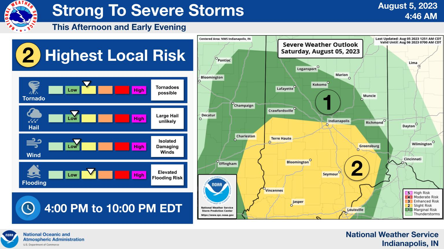
Strong to severe storms will move through this evening. Isolated tornadoes are the primary threat with the storms today along with pockets of flooding.
Flooding threat will be highest north of I-70 with the higher tornado threat to the south.
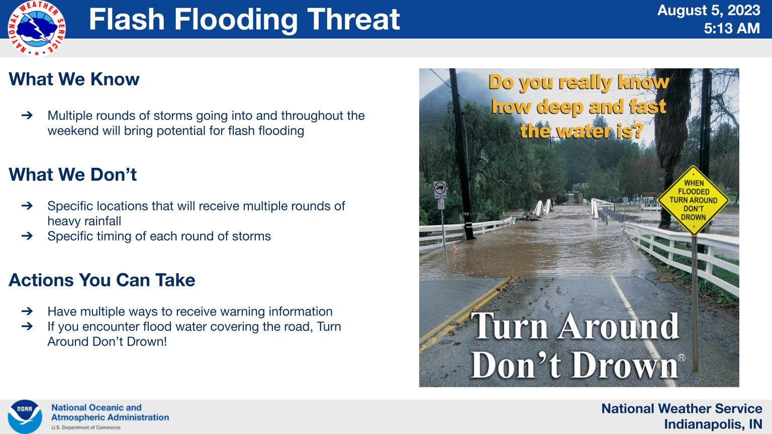
Multiple rounds of storms expected through the weekend may cause isolated flash flooding.
The first round of heavy rain is expected this evening with additional rain chances through Sunday evening. Storms may move slowly at times with periods of very heavy rain.
INDIANAPOLIS DAILY CLIMATE DATA
INDIANAPOLIS 7-DAY EXTENDED FORECAST
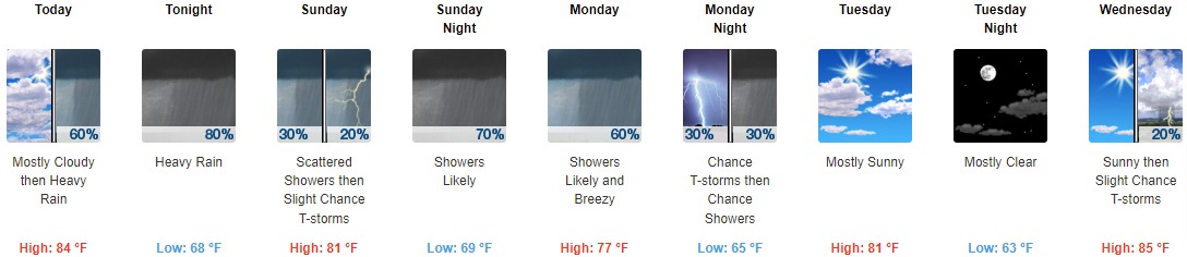
Today: Scattered showers before 2pm, then scattered showers and thunderstorms between 2pm and 5pm, then showers likely and possibly a thunderstorm after 5pm. Some of the storms could produce heavy rainfall. Mostly cloudy, with a high near 84. Southeast wind 5 to 9 mph. Chance of precipitation is 60%. New rainfall amounts between 1 and 2 inches possible.
Tonight: Showers and possibly a thunderstorm, mainly before 1am, then scattered showers and thunderstorms after 1am. Some of the storms could produce heavy rainfall. Low around 68. East wind 9 to 13 mph, with gusts as high as 23 mph. Chance of precipitation is 80%. New rainfall amounts between 1 and 2 inches possible.
Sunday: Scattered showers and thunderstorms before 8am, then a slight chance of showers between 8am and 11am, then a slight chance of showers and thunderstorms after 11am. Mostly cloudy, with a high near 81. South southeast wind 7 to 10 mph becoming west southwest in the afternoon. Chance of precipitation is 30%.
Sunday Night: Showers likely and possibly a thunderstorm. Mostly cloudy, with a low around 69. South wind 6 to 9 mph. Chance of precipitation is 70%. New rainfall amounts between a tenth and quarter of an inch, except higher amounts possible in thunderstorms.
Monday: Showers likely and possibly a thunderstorm. Mostly cloudy, with a high near 77. Breezy, with a west southwest wind 10 to 20 mph, with gusts as high as 28 mph. Chance of precipitation is 60%. New rainfall amounts between a tenth and quarter of an inch, except higher amounts possible in thunderstorms.
Monday Night: A 30 percent chance of showers and thunderstorms before 2am. Mostly cloudy, with a low around 65.
Tuesday: Mostly sunny, with a high near 81.
Tuesday Night: Mostly clear, with a low around 63.
Wednesday: A 20 percent chance of showers and thunderstorms after 2pm. Mostly sunny, with a high near 85.
Wednesday Night: A chance of showers and thunderstorms, then showers likely and possibly a thunderstorm after 2am. Mostly cloudy, with a low around 68. Chance of precipitation is 60%.
Thursday: Showers and thunderstorms likely. Partly sunny, with a high near 83. Chance of precipitation is 60%.
Thursday Night: A 20 percent chance of showers. Partly cloudy, with a low around 65.
Friday: A 20 percent chance of showers and thunderstorms. Mostly sunny, with a high near 82.
THE UNITED STATES OF AMERICA 3-DAY OUTLOOK


SOURCE: NWS Indianapolis.
Follow NWS Indianapolis on Twitter @NWSIndianapolis for the latest Indianapolis area weather news.