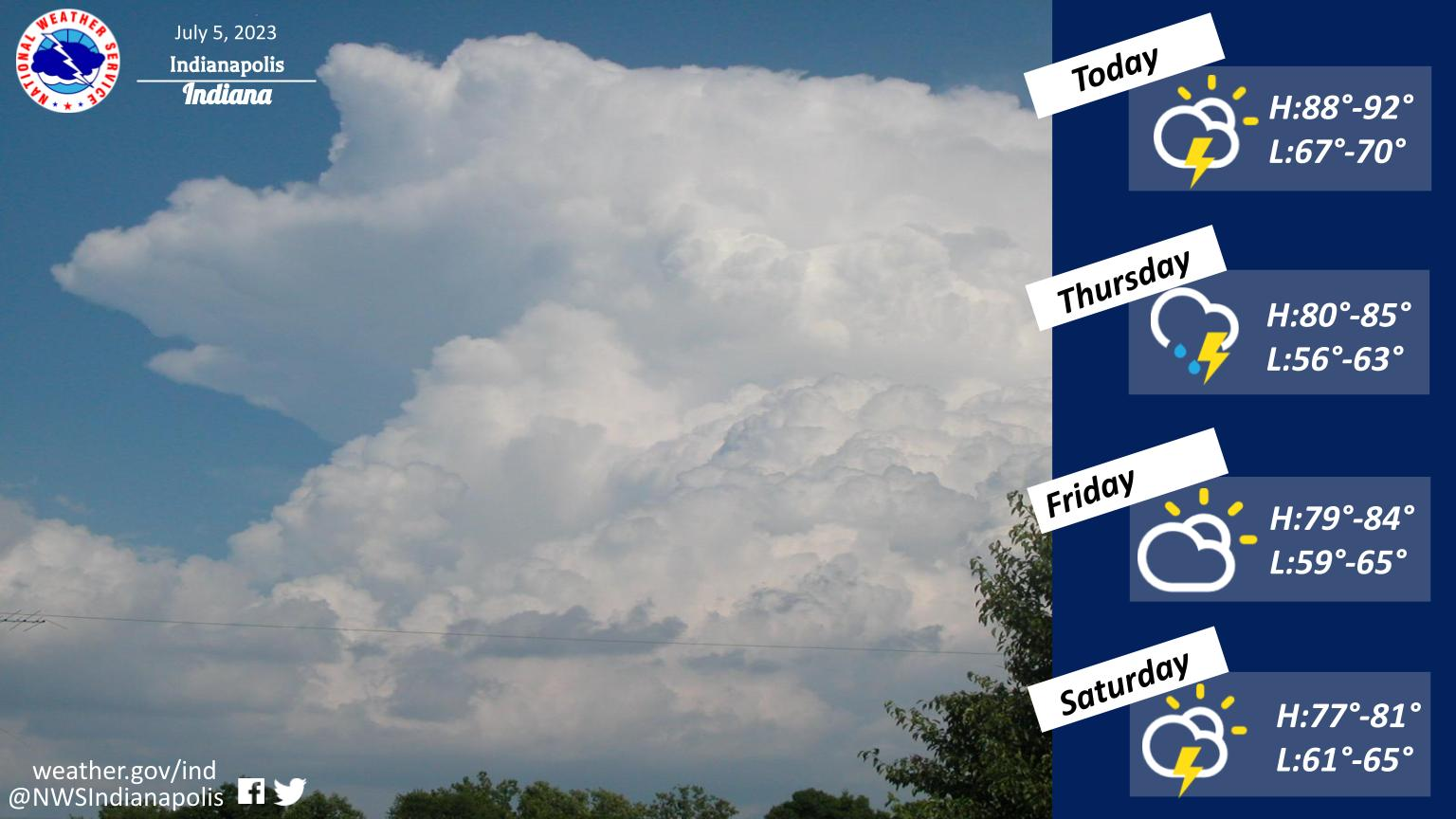
After a hot day today, thunderstorms will increase from the west late this afternoon into this evening ahead of an approaching cold front.
A few of the storms may be severe this evening, especially across western portions of central Indiana.
Chances for showers and storms will continue through Thursday as the front sweeps across the area.
After a brief period of dry weather to end the week, chances for rain and storms will return by Saturday afternoon.
INDIANAPOLIS 7-DAY EXTENDED FORECAST
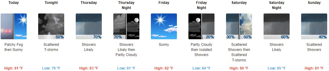
Today: Patchy fog before 10am. Otherwise, sunny and hot, with a high near 91. Calm wind becoming south southwest 5 to 8 mph in the afternoon.
Tonight: Scattered showers and thunderstorms, mainly after 10pm. Increasing clouds, with a low around 70. Southwest wind 5 to 8 mph. Chance of precipitation is 50%. New rainfall amounts between a tenth and quarter of an inch, except higher amounts possible in thunderstorms.
Thursday: Showers likely and possibly a thunderstorm. Mostly cloudy, with a high near 83. Southwest wind 5 to 8 mph becoming west northwest in the afternoon. Chance of precipitation is 70%. New rainfall amounts of less than a tenth of an inch, except higher amounts possible in thunderstorms.
Thursday Night: Showers likely and possibly a thunderstorm before 9pm. Partly cloudy, with a low around 61. North wind 7 to 9 mph. Chance of precipitation is 70%. New precipitation amounts of less than a tenth of an inch, except higher amounts possible in thunderstorms.
Friday: Sunny, with a high near 82. North northeast wind around 7 mph.
Friday Night: Isolated showers after 3am. Partly cloudy, with a low around 64. Chance of precipitation is 20%.
Saturday: Isolated showers and thunderstorms before 9am, then scattered showers between 9am and 3pm, then scattered showers and thunderstorms after 3pm. Partly sunny, with a high near 80. Chance of precipitation is 50%.
Saturday Night: Scattered showers and thunderstorms before 9pm, then showers likely and possibly a thunderstorm between 9pm and 3am, then scattered showers after 3am. Mostly cloudy, with a low around 65. Chance of precipitation is 60%.
Sunday: Scattered showers, with thunderstorms also possible after 3pm. Mostly cloudy, with a high near 81. Chance of precipitation is 40%.
Sunday Night: Scattered showers and thunderstorms. Mostly cloudy, with a low around 64. Chance of precipitation is 40%.
Monday: Scattered showers and thunderstorms. Mostly sunny, with a high near 83. Chance of precipitation is 40%.
Monday Night: Scattered showers and thunderstorms. Partly cloudy, with a low around 65. Chance of precipitation is 40%.
Tuesday: Isolated showers and thunderstorms. Mostly sunny, with a high near 84. Chance of precipitation is 20%.
THE UNITED STATES OF AMERICA 3-DAY OUTLOOK


SOURCE: NWS Indianapolis.
Follow NWS Indianapolis on Twitter @NWSIndianapolis for the latest Indianapolis area weather news.