Dry and seasonal conditions are expected Today through the day on Wednesday before some uncertainty pops into the forecast with thunderstorms possible as early as Wednesday evening.
Temperatures and humidity are also expected to increase late this week with highs in the upper 80s and dew points in the upper 60s beginning Friday.
INDIANAPOLIS 7-DAY EXTENDED FORECAST
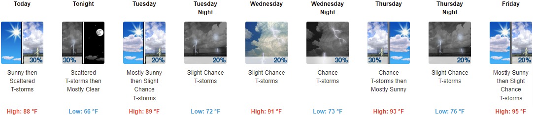
This Afternoon: Sunny, with a high near 83. North wind around 8 mph.
Tonight: Mostly clear, with a low around 62. East northeast wind 5 to 7 mph.
Tuesday: Sunny, with a high near 85. Calm wind becoming east southeast around 6 mph in the morning.
Tuesday Night: Partly cloudy, with a low around 64. East wind around 7 mph.
Wednesday: Partly sunny, with a high near 85. South wind 7 to 9 mph.
Wednesday Night: A 40 percent chance of showers. Mostly cloudy, with a low around 67.
Thursday: A chance of showers, with thunderstorms also possible after 2pm. Partly sunny, with a high near 87. Chance of precipitation is 30%.
Thursday Night: A slight chance of showers and thunderstorms. Mostly cloudy, with a low around 70. Chance of precipitation is 20%.
Friday: A slight chance of showers, then a chance of showers and thunderstorms after 2pm. Mostly sunny, with a high near 90. Chance of precipitation is 30%.
Friday Night: A chance of showers and thunderstorms before 2am, then a slight chance of showers. Partly cloudy, with a low around 68. Chance of precipitation is 30%.
Saturday: A 20 percent chance of showers and thunderstorms. Mostly sunny, with a high near 86.
Saturday Night: A 20 percent chance of showers and thunderstorms. Partly cloudy, with a low around 67.
Sunday: A 20 percent chance of showers and thunderstorms. Mostly sunny, with a high near 88.
THE UNITED STATES OF AMERICA 3-DAY OUTLOOK


SOURCE: NWS Indianapolis.
Follow NWS Indianapolis on Twitter @NWSIndianapolis for the latest Indianapolis area weather news.