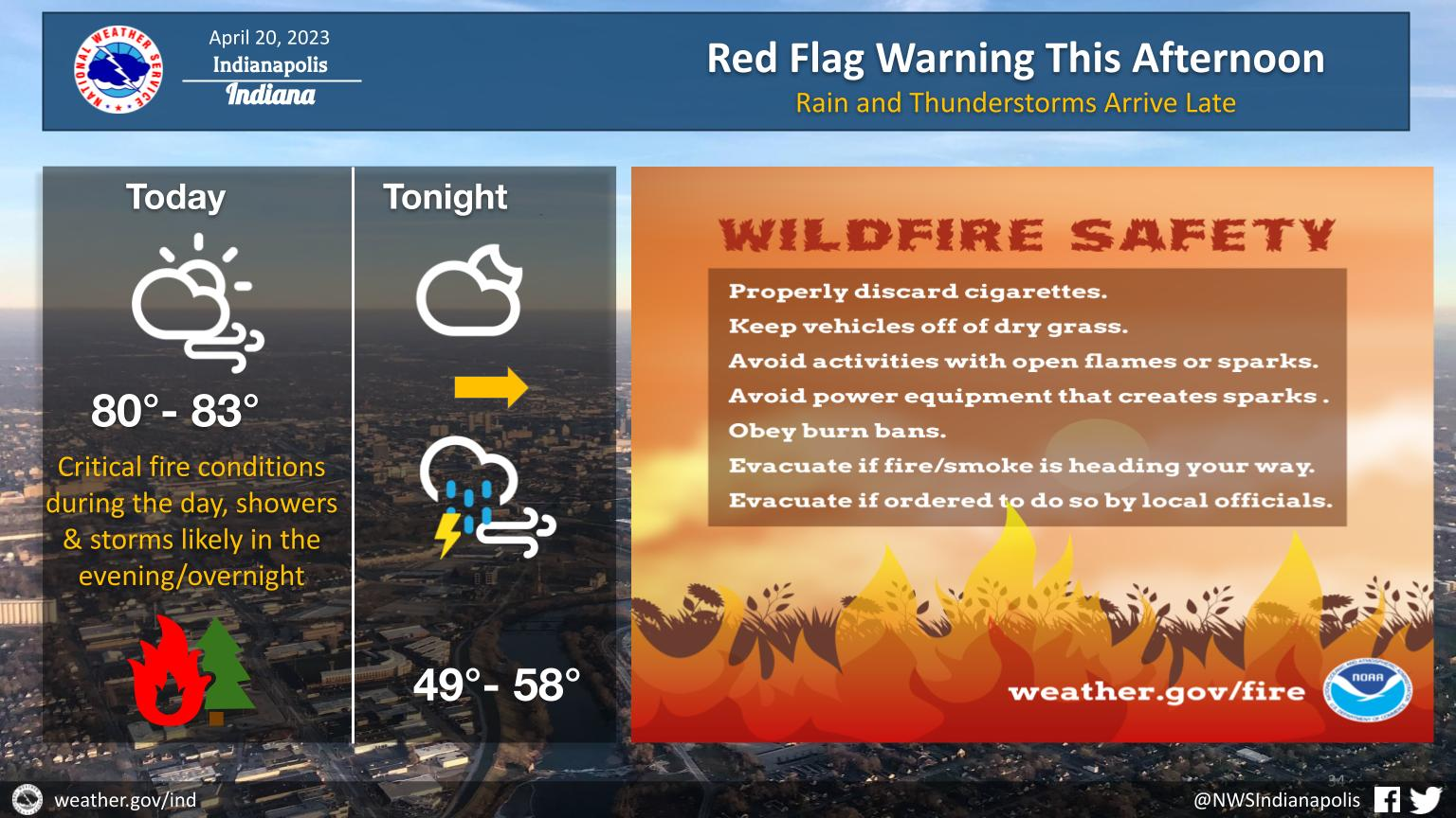
Windy today with red flag conditions this afternoon and showers and thunderstorms moving in from NW-SE tonight.
Do not do outdoor burning today!
RED FLAG WARNING
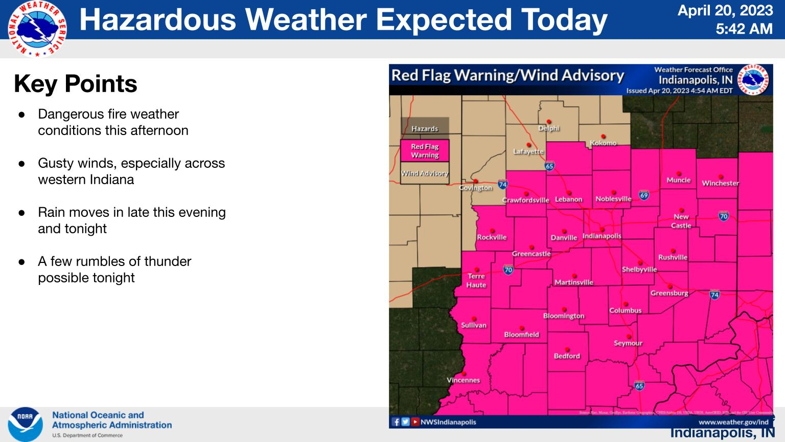
RED FLAG WARNING IN EFFECT FROM NOON TODAY TO 8 PM EDT THIS EVENING FOR CRITICAL FIRE WEATHER CONDITIONS
The National Weather Service in Indianapolis has issued a Red Flag Warning for critical fire weather conditions, which is in effect from noon today to 8 PM EDT this evening.
AFFECTED AREA…Much of central Indiana.
TIMING…Noon until 8 PM EDT on Thursday.
WINDS…South 20 to 25 mph with gusts up to 40 mph.
RELATIVE HUMIDITY…As low as 20 percent.
TEMPERATURES…In the low 80s.
IMPACTS…Any fires that develop will likely spread rapidly. Outdoor burning is not recommended. Never throw cigarettes out of a vehicle.
PRECAUTIONARY/PREPAREDNESS ACTIONS…A Red Flag Warning means that critical fire weather conditions are either occurring now, or will shortly. A combination of strong winds, low relative humidity, and warm temperatures can contribute to extreme fire behavior.
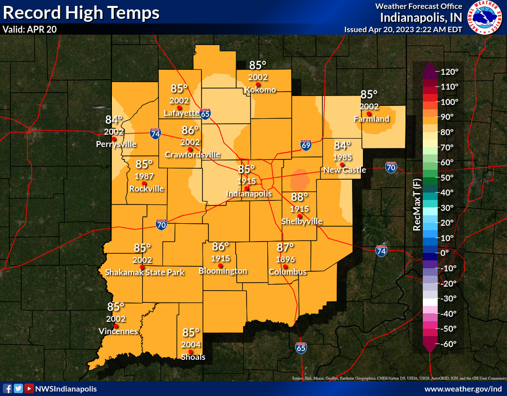
AVERAGES AND RECORDS
INDIANAPOLIS 7-DAY EXTENDED FORECAST
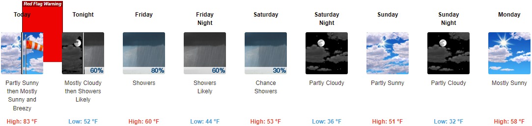
Today: Mostly sunny, with a high near 83. Breezy, with a south southwest wind 8 to 13 mph increasing to 16 to 21 mph in the afternoon. Winds could gust as high as 34 mph.
Tonight: Scattered showers and thunderstorms, then showers likely and possibly a thunderstorm after 5am. Increasing clouds, with a low around 52. South southwest wind 10 to 14 mph, with gusts as high as 28 mph. Chance of precipitation is 60%. New rainfall amounts between a tenth and quarter of an inch, except higher amounts possible in thunderstorms.
Friday: Showers and possibly a thunderstorm. High near 60. North wind 6 to 10 mph becoming west in the afternoon. Chance of precipitation is 80%. New precipitation amounts between three quarters and one inch possible.
Friday Night: Showers likely, mainly before 2am. Mostly cloudy, with a low around 44. East wind 7 to 11 mph becoming west northwest after midnight. Chance of precipitation is 60%. New precipitation amounts between a tenth and quarter of an inch possible.
Saturday: A 30 percent chance of showers. Partly sunny, with a high near 53. West wind 10 to 18 mph, with gusts as high as 26 mph.
Saturday Night: Partly cloudy, with a low around 36.
Sunday: Partly sunny, with a high near 51.
Sunday Night: Partly cloudy, with a low around 32.
Monday: Mostly sunny, with a high near 58.
Monday Night: Partly cloudy, with a low around 40.
Tuesday: A 20 percent chance of showers. Mostly sunny, with a high near 64.
Tuesday Night: A 30 percent chance of showers. Mostly cloudy, with a low around 45.
Wednesday: A 40 percent chance of showers. Mostly cloudy, with a high near 61.
THE UNITED STATES OF AMERICA 3-DAY OUTLOOK


SOURCE: NWS Indianapolis.
Follow NWS Indianapolis on Twitter @NWSIndianapolis for the latest Indianapolis area weather news.