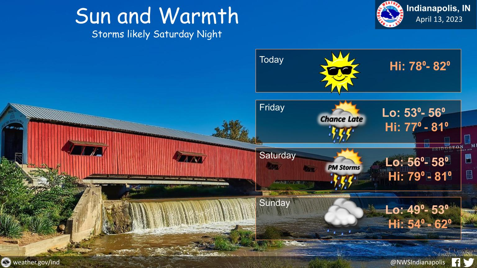
Expect Sunny skies today with highs near 80°.
There are small chances for a shower or storm on Friday Afternoon.
However, chances for showers and storms are much higher on Saturday afternoon and Saturday night.
KNOZONE ACTION DAY
The officials at the Office of Sustainability for the City of Indianapolis have called for a Knozone Action Day on Thursday, April 13 for Marion County. This will be the first Knozone Action Day for 2023.
This Knozone Action Day will be in effect from 12:00 AM to 11:59 PM.
A Knozone Action Day means that a combination of the high temperatures, light winds, and other factors, are expected to produce conditions where high levels of ozone emissions may exceed federally mandated standards.
Additionally, wildfire smoke from the west continues to blow over and present on satellites all over Indiana. While this is not causing these specific Knozone Action Days, scientists will continue to monitor the levels of PM2.5 caused by these natural disasters over the coming days and weeks and issue any additional alerts if necessary.
Here are some recommended actions that the public can take to reduce ozone forming emissions:
- Walk, bike, carpool or use public transportation. Be aware of your surroundings.
- Avoid using the drive-through and combine errands into one trip.
- Avoid refueling your vehicle or using gasoline-powered lawn equipment until after 7 PM.
- Turn off your engine when idling for more than 30 seconds.
- Conserve energy by turning off lights or setting the air conditioner to 75 degrees or above.
- Delay use of garden, household, and workshop chemicals until air has returned to healthy levels
- Never burn trash. Burning trash is illegal in Marion County, and the rules and regulations for open burning are available on the Department of Business and Neighborhood Services’ website: indy.gov/BNS
INDIANAPOLIS 7-DAY EXTENDED FORECAST
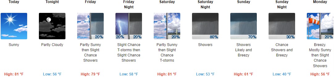
Today: Sunny, with a high near 81. Southwest wind 5 to 8 mph.
Tonight: Partly cloudy, with a low around 56. South wind around 6 mph becoming light and variable.
Friday: A 20 percent chance of showers after 2pm. Partly sunny, with a high near 79. East northeast wind 5 to 7 mph becoming south southeast in the morning.
Friday Night: A slight chance of showers and thunderstorms before 11pm, then a slight chance of showers between 11pm and 2am. Mostly cloudy, with a low around 58. Southeast wind 6 to 8 mph. Chance of precipitation is 20%.
Saturday: A slight chance of showers between 2pm and 5pm, then a slight chance of showers and thunderstorms after 5pm. Partly sunny, with a high near 81. South southwest wind 6 to 11 mph. Chance of precipitation is 20%.
Saturday Night: A slight chance of showers and thunderstorms, then showers and possibly a thunderstorm after 8pm. Low around 53. Chance of precipitation is 80%. New rainfall amounts of less than a tenth of an inch, except higher amounts possible in thunderstorms.
Sunday: Showers likely, mainly before 2pm. Mostly cloudy, with a high near 61. Breezy. Chance of precipitation is 70%.
Sunday Night: A 30 percent chance of showers before 2am. Mostly cloudy, with a low around 40. Breezy.
Monday: A 20 percent chance of showers after 2pm. Mostly sunny, with a high near 56. Breezy.
Monday Night: A 10 percent chance of showers before 8pm. Mostly clear, with a low around 39. Breezy.
Tuesday: Sunny, with a high near 67.
Tuesday Night: Partly cloudy, with a low around 45.
Wednesday: Mostly sunny, with a high near 75.
THE UNITED STATES OF AMERICA 3-DAY OUTLOOK


SOURCE: NWS Indianapolis.
Follow NWS Indianapolis on Twitter @NWSIndianapolis for the latest Indianapolis area weather news.