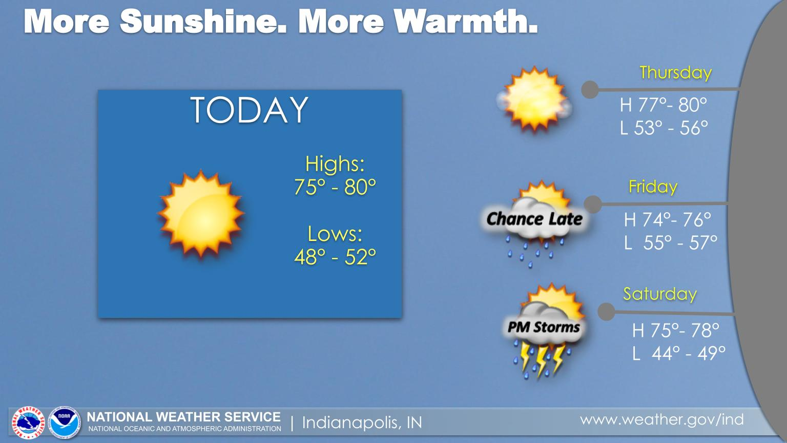
Expect Sunny Skies Today and Thursday with highs in the upper 70s to near 80°.
Small chances for showers will return on Friday afternoon, with better chances for rain and thunderstorms on Saturday afternoon and Saturday Night.
ELEVATED FIRE RISK TODAY
Dry and breezy conditions will create an elevated fire risk across portions of central Indiana this afternoon. West-southwest winds will increase during the day, peaking around 15mph, with gusts up to 25mph this afternoon. This in combination with relative humidity values around 30 percent and dry vegetation will lead to an elevated risk of fire spreading quickly. Outdoor burning should be avoided if possible, and any equipment that could generate sparks should be handled with extra care.
Carroll County, Warren County, Tippecanoe County, Clinton County, Howard County, Fountain County, Montgomery County, Boone County, Tipton County, Hamilton County, Madison County, Delaware County, Randolph County, Vermillion County, Parke County, Putnam County, Hendricks County, Marion County, Hancock County, Henry County, Vigo County, and Clay County.
Including the cities of Delphi Indiana, Flora Indiana, Williamsport Indiana, West Lebanon Indiana, Lafayette Indiana, West Lafayette Indiana, Frankfort Indiana, Kokomo Indiana, Attica Indiana, Covington Indiana, Veedersburg Indiana, Crawfordsville Indiana, Lebanon Indiana, Zionsville Indiana, Tipton Indiana, Fishers Indiana, Carmel Indiana, Noblesville Indiana, Anderson Indiana, Muncie Indiana, Winchester Indiana, Union City Indiana, Farmland Indiana, Parker City Indiana, Clinton Indiana, Fairview Park Indiana, Rockville Indiana, Montezuma Indiana, Rosedale Indiana, Greencastle Indiana, Plainfield Indiana, Brownsburg Indiana, Danville Indiana, Indianapolis Indiana, Greenfield Indiana, New Castle Indiana, Terre Haute Indiana, and Brazil Indiana
INDIANAPOLIS 7-DAY EXTENDED FORECAST
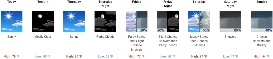
Today: Sunny, with a high near 79. Southwest wind 7 to 13 mph, with gusts as high as 21 mph.
Tonight: Mostly clear, with a low around 50. South southwest wind 7 to 10 mph.
Thursday: Sunny, with a high near 80. South southwest wind 5 to 9 mph.
Thursday Night: Partly cloudy, with a low around 55. South southeast wind around 7 mph.
Friday: A 20 percent chance of showers after 3pm. Partly sunny, with a high near 77. South southeast wind 6 to 8 mph.
Friday Night: A 20 percent chance of showers before 9pm. Partly cloudy, with a low around 57.
Saturday: A 50 percent chance of showers and thunderstorms after 3pm. Partly sunny, with a high near 77.
Saturday Night: A chance of showers and thunderstorms before 9pm, then showers and possibly a thunderstorm between 9pm and 3am, then a chance of showers after 3am. Low around 47. Chance of precipitation is 80%.
Sunday: A 40 percent chance of showers. Mostly cloudy, with a high near 54. Breezy.
Sunday Night: A 30 percent chance of showers before 9pm. Mostly cloudy, with a low around 42. Breezy.
Monday: Mostly sunny, with a high near 54. Breezy.
Monday Night: Mostly cloudy, with a low around 39. Breezy.
Tuesday: Mostly sunny, with a high near 58.
THE UNITED STATES OF AMERICA 3-DAY OUTLOOK


SOURCE: NWS Indianapolis.
Follow NWS Indianapolis on Twitter @NWSIndianapolis for the latest Indianapolis area weather news.