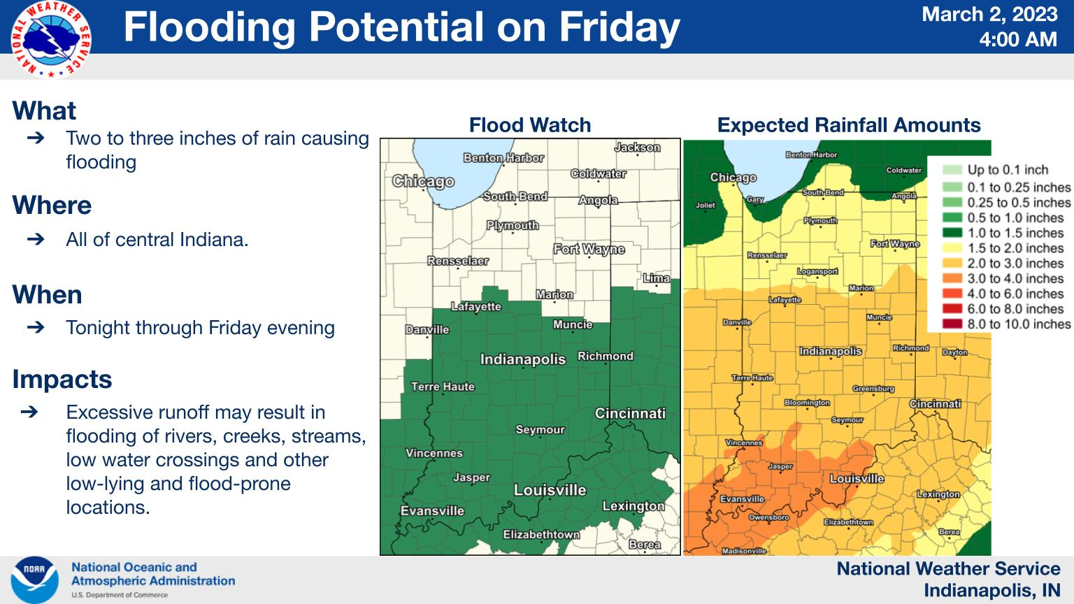
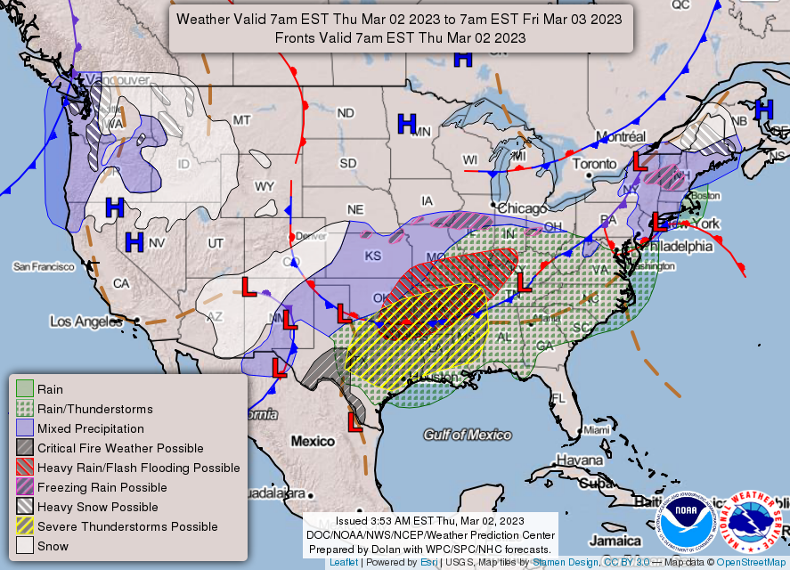
Rain will begin tonight and continuing through Friday.
2-3 inches of rain could lead to flooding of low-lying flood-prone locations and rivers.
COOLER TEMPERATURES COMING
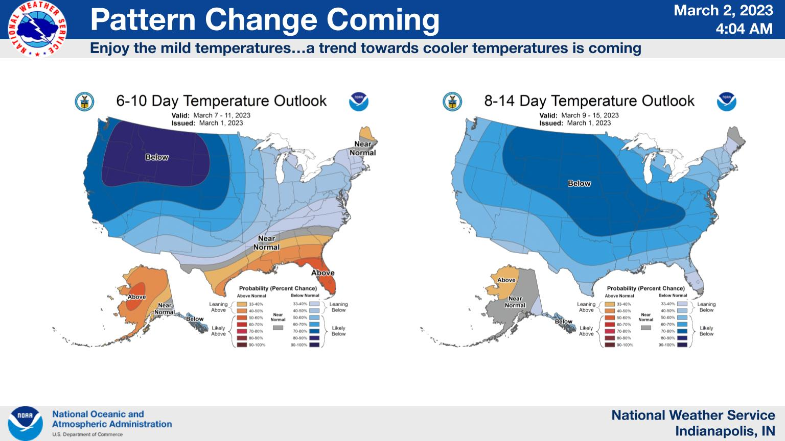
Guidance continues to indicate that the atmospheric pattern is about to change and trend towards a slightly cooler than normal setup for a period of time in the month of March.
This is the latest extended temperature outlook issued by the Climate Prediction Center.
FLOOD WATCH VS. FLOOD WARNING
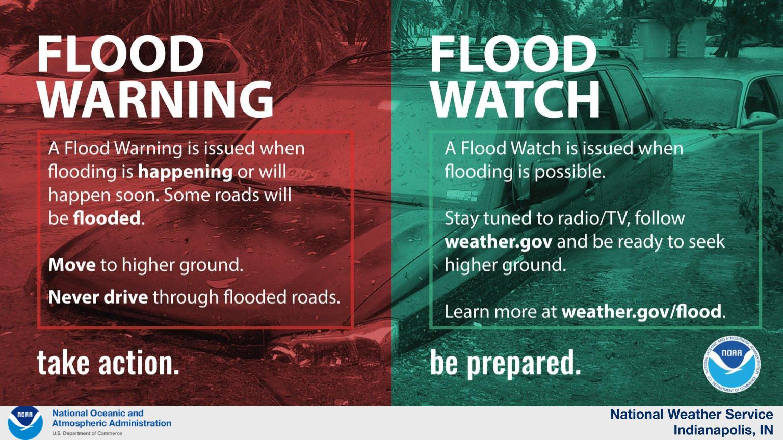
A flood watch is in effect for most of central Indiana.
A flood watch means flooding is possible.
A flood warning means flooding is occurring.
FLOOD WATCH IN EFFECT FROM LATE TONIGHT THROUGH LATE FRIDAY NIGHT
National Weather Service Indianapolis, Indiana
2:42 AM EST Thursday, March 2, 2023
Indiana Counties: Carroll County, Warren County, Tippecanoe County, Clinton County, Howard County, Fountain County, Montgomery County, Boone County, Tipton County, Hamilton County, Madison County, Delaware County, Randolph County, Vermillion County, Parke County, Putnam County, Hendricks County, Marion County, Hancock County, Henry County, Vigo County, Clay County, Owen County, Morgan County, Johnson County, Shelby County, Rush County, Sullivan County, Greene County, Monroe County, Brown County, Bartholomew County, Decatur County, Knox County, Daviess County, Martin County, Lawrence County, Jackson County, and Jennings County.
Including the cities of Shelburn Indiana, West Lebanon Indiana, Gosport Indiana, Franklin Indiana, Delphi Indiana, Rosedale Indiana, Winchester Indiana, Sullivan Indiana, Farmersburg Indiana, Bloomfield Indiana, Nashville Indiana, Vincennes Indiana, Bedford Indiana, Jasonville Indiana, Crawfordsville Indiana, Attica Indiana, Mitchell Indiana, Union City Indiana, Farmland Indiana, Fairview Park Indiana, West Lafayette Indiana, Danville Indiana, Greenwood Indiana, Martinsville Indiana, Shoals Indiana, Flora Indiana, North Vernon Indiana, Fishers Indiana, Tipton Indiana, Covington Indiana, Carlisle Indiana, Indianapolis Indiana, Plainfield Indiana, Washington Indiana, Clinton Indiana, Lafayette Indiana, Zionsville Indiana, Columbus Indiana, Frankfort Indiana, Mooresville Indiana, Terre Haute Indiana, Worthington Indiana, Anderson Indiana, Brazil Indiana, Brownsburg Indiana, Williamsport Indiana, Seymour Indiana, Carmel Indiana, Linton Indiana, Loogootee Indiana, Noblesville Indiana, Muncie Indiana, Spencer Indiana, Veedersburg Indiana, Rushville Indiana, Montezuma Indiana, Greensburg Indiana, Greenfield Indiana, Shelbyville Indiana, Kokomo Indiana, Lebanon Indiana, Bloomington Indiana, New Castle Indiana, Greencastle Indiana, Parker City Indiana, and Rockville Indiana.
WHAT
Flooding caused by excessive rainfall is possible.
WHERE
Portions of central Indiana, east central Indiana, north central Indiana, south central Indiana, southeast Indiana, southwest Indiana and west central Indiana, including the following counties;
In Central Indiana, Bartholomew, Boone, Clinton, Decatur, Hamilton, Hancock, Hendricks, Howard, Johnson, Madison, Marion, Morgan, Rush, Shelby and Tipton.
In East Central Indiana, Delaware, Henry and Randolph.
In North Central Indiana, Carroll.
In South Central Indiana, Brown, Jackson, Lawrence and Monroe.
In Southeast Indiana, Jennings.
In Southwest Indiana, Daviess, Greene, Knox, Martin and Sullivan.
In West Central Indiana, Clay, Fountain, Montgomery, Owen, Parke, Putnam, Tippecanoe, Vermillion, Vigo and Warren.
WHEN
From late tonight through late Friday night.
IMPACTS
Excessive runoff may result in flooding of rivers, creeks, streams, and other low-lying and flood-prone locations.
ADDITIONAL DETAILS
- Moderate to at times heavy rain will overspread much of Central Indiana late tonight, then persist through much of the day Friday.
- Rainfall totals of 2 to 3 inches are currently forecast for the region. Locally higher amounts are possible.
- This amount of rain may cause flooding of low water crossings, creeks, and streams.
- http://www.weather.gov/safety/flood
PRECAUTIONARY/PREPAREDNESS ACTIONS
You should monitor later forecasts and be alert for possible Flood Warnings. Those living in areas prone to flooding should be prepared to take action should flooding develop.
INDIANAPOLIS 7-DAY EXTENDED FORECAST
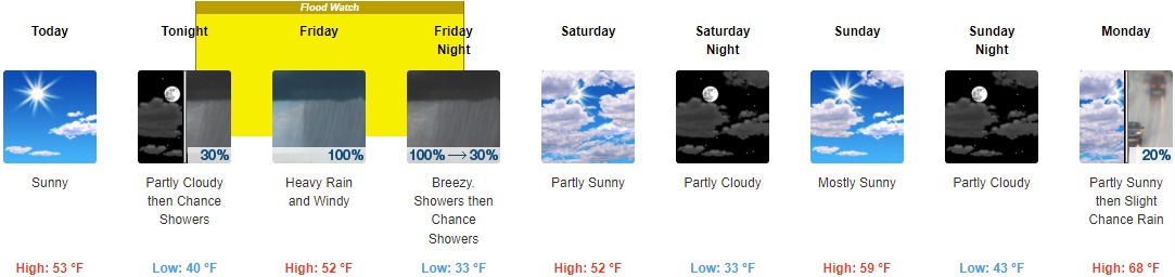
Today: Sunny, with a high near 53. North wind 7 to 10 mph.
Tonight: A 30 percent chance of showers, mainly after 5am. Increasing clouds, with a low around 40. Northeast wind 8 to 15 mph, with gusts as high as 22 mph.
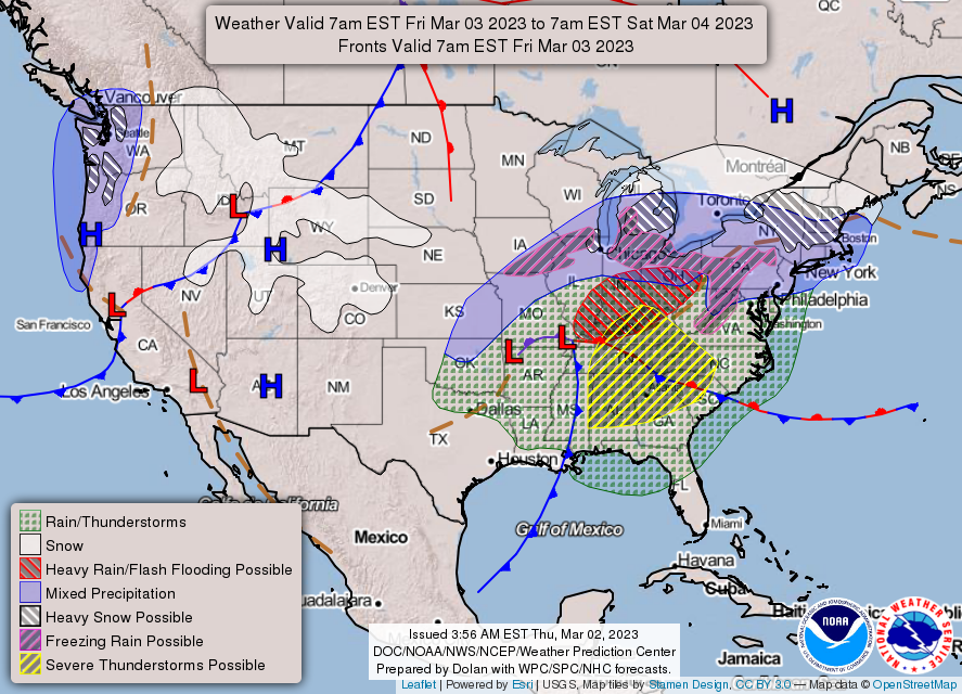
Friday: Showers, with thunderstorms also possible after 11am. Some of the storms could produce heavy rainfall. High near 52. Windy, with an east wind 18 to 23 mph increasing to 25 to 30 mph in the morning. Winds could gust as high as 46 mph. Chance of precipitation is 100%. New rainfall amounts between 1 and 2 inches possible.
Friday Night: Showers, mainly before 1am. Low around 33. Breezy, with a west wind 18 to 25 mph, with gusts as high as 38 mph. Chance of precipitation is 100%. New precipitation amounts between a quarter and half of an inch possible.
Saturday: Partly sunny, with a high near 52. West northwest wind 9 to 16 mph, with gusts as high as 23 mph.
Saturday Night: Partly cloudy, with a low around 33.
Sunday: Mostly sunny, with a high near 59.
Sunday Night: Partly cloudy, with a low around 43.
Monday: A 20 percent chance of rain after 2pm. Mostly sunny, with a high near 68.
Monday Night: A 30 percent chance of rain, mainly between 8pm and 2am. Mostly cloudy, with a low around 41.
Tuesday: Partly sunny, with a high near 55.
Tuesday Night: Mostly cloudy, with a low around 34.
Wednesday: Partly sunny, with a high near 47.
THE UNITED STATES OF AMERICA 3-DAY OUTLOOK

SOURCE: NWS Indianapolis.
Follow NWS Indianapolis on Twitter @NWSIndianapolis for the latest Indianapolis area weather news.