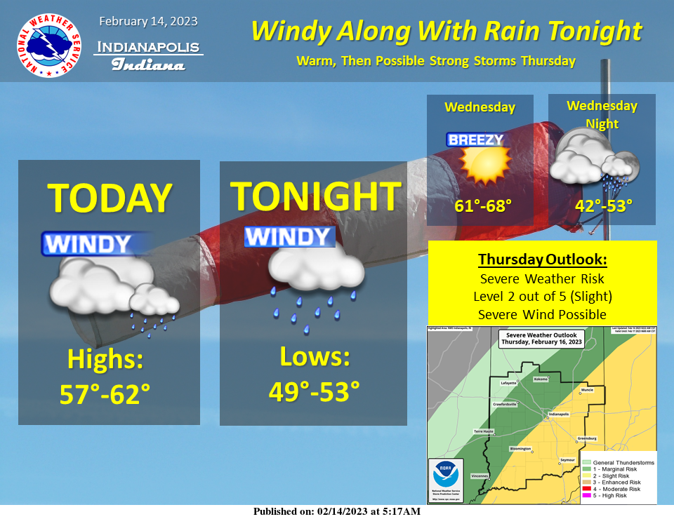
Warm conditions again today with windy conditions late today through early tomorrow.
A brief period of rain is likely late this evening.
Even warmer conditions for tomorrow before storm chances arrive late Wednesday night into Thursday.
A few strong storms are possible.
WIND ADVISORY
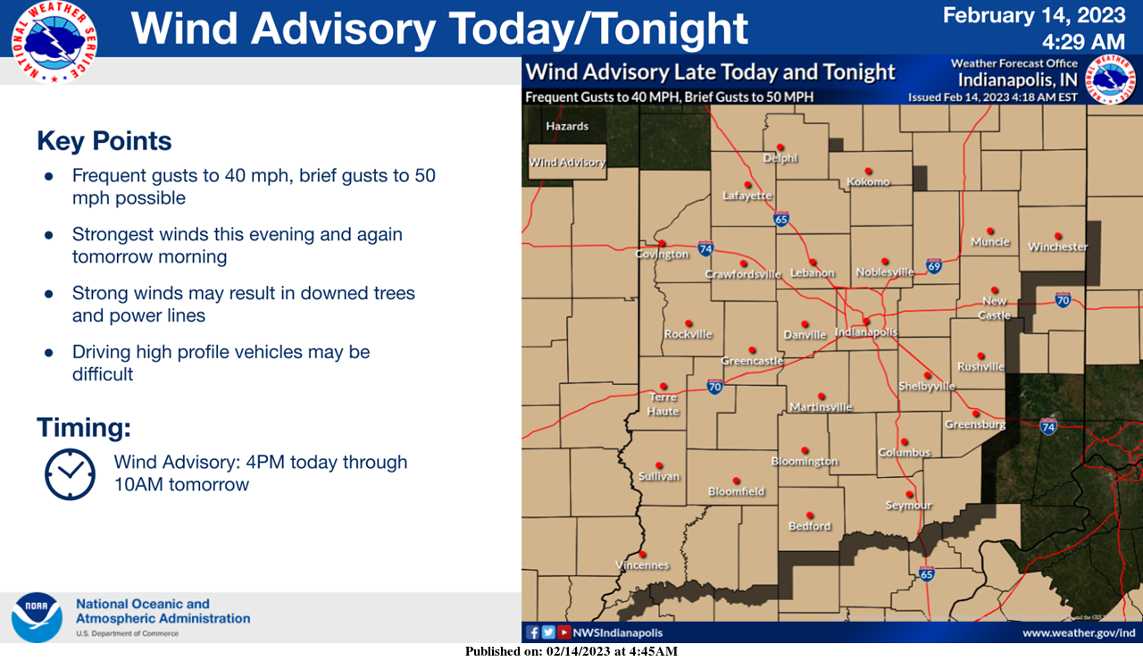
A Wind Advisory has been issued from 4PM today to 10AM tomorrow.
Frequent southerly wind gusts of 40 mph are expected with brief 50 mph wind gusts possible, especially late today and early tomorrow.
Watch out for isolated power outages and difficult travel conditions.
URGENT – WEATHER MESSAGE
National Weather Service Indianapolis, Indiana
3:18 AM EST Tuesday, February 14, 2023
Carroll County, Warren County, Tippecanoe County, Clinton County, Howard County, Fountain County, Montgomery County, Boone County, Tipton County, Hamilton County, Madison County, Delaware County, Randolph County, Vermillion County, Parke County, Putnam County, Hendricks County, Marion County, Hancock County, Henry County, Vigo County, Clay County, Owen County, Morgan County, Johnson County, Shelby County, Rush County, Sullivan County, Greene County, Monroe County, Brown County, Bartholomew County, Decatur County, Knox County, Daviess County, Martin County, Lawrence County, Jackson County, and Jennings County.
Including the cities of Delphi Indiana, Flora Indiana, Williamsport Indiana, West Lebanon Indiana, Lafayette Indiana, West Lafayette Indiana, Frankfort Indiana, Kokomo Indiana, Attica Indiana, Covington Indiana, Veedersburg Indiana, Crawfordsville Indiana, Lebanon Indiana, Zionsville Indiana, Tipton Indiana, Fishers Indiana, Carmel Indiana, Noblesville Indiana, Anderson Indiana, Muncie Indiana, Winchester Indiana, Union City Indiana, Farmland Indiana, Parker City Indiana, Clinton Indiana, Fairview Park Indiana, Rockville Indiana, Montezuma Indiana, Rosedale Indiana, Greencastle Indiana, Plainfield Indiana, Brownsburg Indiana, Danville Indiana, Indianapolis Indiana, Greenfield Indiana, New Castle Indiana, Terre Haute Indiana, Brazil Indiana, Spencer Indiana, Gosport Indiana, Martinsville Indiana, Mooresville Indiana, Greenwood Indiana, Franklin Indiana, Shelbyville Indiana, Rushville Indiana, Sullivan Indiana, Carlisle Indiana, Shelburn Indiana, Farmersburg Indiana, Linton Indiana, Bloomfield Indiana, Jasonville Indiana, Worthington Indiana, Bloomington Indiana, Nashville Indiana, Columbus Indiana, Greensburg Indiana, Vincennes Indiana, Washington Indiana, Loogootee Indiana, Shoals Indiana, Bedford Indiana, Mitchell Indiana, Seymour Indiana, and North Vernon Indiana.
WIND ADVISORY IN EFFECT FROM 4 PM THIS AFTERNOON TO 10 AM EST WEDNESDAY
WHAT…South winds 15 to 25 mph with frequent gusts up to 40 mph expected. Brief gusts up to 50 mph possible.
WHERE…Portions of central, east central, north central, south central, southeast, southwest and west central Indiana.
WHEN…From 4 PM this afternoon to 10 AM EST Wednesday.
IMPACTS…Gusty winds could blow around unsecured objects. Tree limbs could be blown down and a few power outages may result.
ADDITIONAL DETAILS…Strongest winds will be this evening and again tomorrow morning.
PRECAUTIONARY/PREPAREDNESS ACTIONS
Use extra caution when driving, especially if operating a high profile vehicle. Secure outdoor objects.
INDIANAPOLIS 7-DAY EXTENDED FORECAST
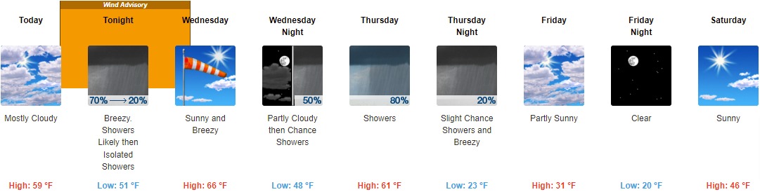
Today: Mostly cloudy, with a high near 59. South southeast wind 9 to 17 mph, with gusts as high as 28 mph.
Tonight: Showers likely before 1am, then scattered sprinkles with isolated showers between 1am and 3am, then scattered sprinkles after 3am. Mostly cloudy, with a low around 51. Breezy, with a south wind around 23 mph, with gusts as high as 40 mph. Chance of precipitation is 70%. New precipitation amounts of less than a tenth of an inch possible.
Wednesday: Sunny, with a high near 66. Breezy, with a southwest wind 15 to 23 mph, with gusts as high as 41 mph.
Wednesday Night: A 50 percent chance of showers and thunderstorms after 1am. Increasing clouds, with a low around 48. Southwest wind 5 to 7 mph becoming east after midnight. New rainfall amounts between a tenth and quarter of an inch, except higher amounts possible in thunderstorms.
Thursday: Showers and possibly a thunderstorm before 4pm, then showers likely. High near 61. East wind 9 to 17 mph becoming west in the afternoon. Winds could gust as high as 28 mph. Chance of precipitation is 80%. New rainfall amounts between a quarter and half of an inch possible.
Thursday Night: A 20 percent chance of showers before 1am. Mostly cloudy, with a low around 23. Breezy.
Friday: Partly sunny, with a high near 31.
Friday Night: Clear, with a low around 20.
Saturday: Sunny, with a high near 46.
Saturday Night: Mostly cloudy, with a low around 32.
Sunday: Mostly sunny, with a high near 52.
Sunday Night: A 30 percent chance of showers. Mostly cloudy, with a low around 41.
Washington’s Birthday: A 40 percent chance of showers. Mostly cloudy, with a high near 58.
THE UNITED STATES OF AMERICA 3-DAY OUTLOOK


SOURCE: NWS Indianapolis.
Follow NWS Indianapolis on Twitter @NWSIndianapolis for the latest Indianapolis area weather news.