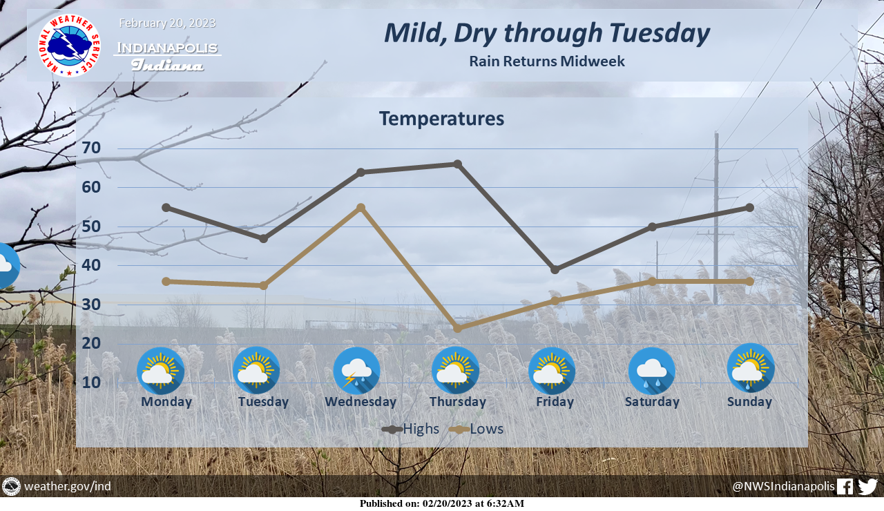
Mild, dry conditions will continue for the next couple days before unsettled weather arrives midweek.
Shower and thunderstorms chances begin Wednesday morning and continue into Wednesday night.
INDIANAPOLIS 7-DAY EXTENDED FORECAST
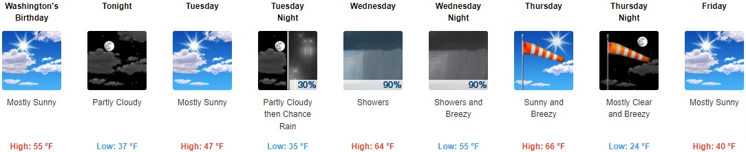
Washington’s Birthday: Mostly sunny, with a high near 55. Light and variable wind becoming west 5 to 10 mph in the afternoon. Winds could gust as high as 22 mph.
Tonight: Partly cloudy, with a low around 37. West wind 5 to 14 mph, with gusts as high as 25 mph.
Tuesday: Mostly sunny, with a high near 47. West northwest wind 9 to 18 mph, with gusts as high as 26 mph.
Tuesday Night: A 30 percent chance of rain after 1am. Increasing clouds, with a low around 35. Light east southeast wind increasing to 10 to 15 mph in the evening. Winds could gust as high as 23 mph.
Wednesday: Showers and possibly a thunderstorm. High near 64. South wind 10 to 15 mph, with gusts as high as 20 mph. Chance of precipitation is 90%. New rainfall amounts between a half and three quarters of an inch possible.
Wednesday Night: Showers and possibly a thunderstorm before 10pm, then rain, mainly between 10pm and 1am. Low around 55. Breezy. Chance of precipitation is 90%. New precipitation amounts between a quarter and half of an inch possible.
Thursday: Sunny, with a high near 66. Breezy.
Thursday Night: Mostly clear, with a low around 24. Breezy.
Friday: Mostly sunny, with a high near 40.
Friday Night: A 40 percent chance of rain after 1am. Mostly cloudy, with a low around 31.
Saturday: A 30 percent chance of rain. Mostly cloudy, with a high near 51.
Saturday Night: A 40 percent chance of rain. Mostly cloudy, with a low around 37.
Sunday: A 20 percent chance of rain. Partly sunny, with a high near 55.
THE UNITED STATES OF AMERICA 3-DAY OUTLOOK


SOURCE: NWS Indianapolis.
Follow NWS Indianapolis on Twitter @NWSIndianapolis for the latest Indianapolis area weather news.