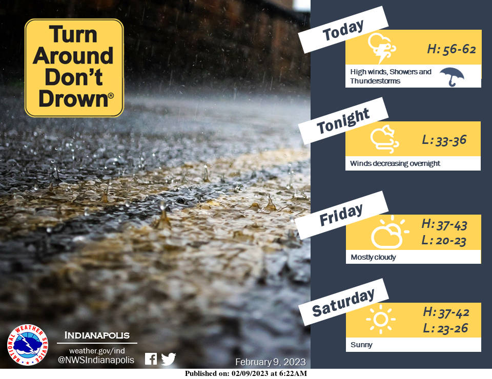
Today will see breezy conditions with gusts in excess of 40mph in some locations.
Much of central Indiana will see rainfall amounts ranging from a trace to more than a quarter of an inch. This could lead to some localized lowland flooding. Do not drive through flooded areas.
GUSTY WINDS TODAY
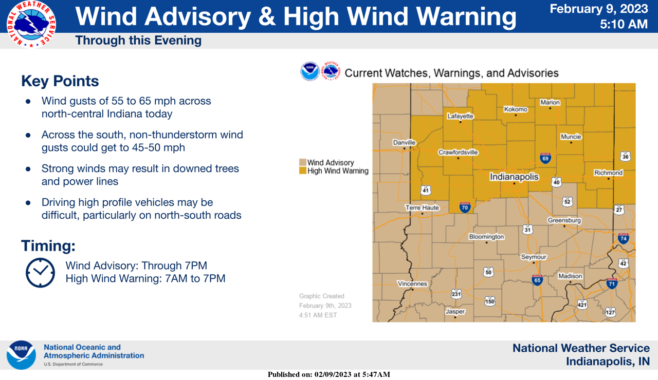
Within and behind the rain, gusty and potentially damaging winds will persist through much of the day today.
South-central Indiana could see gusts of 45 to 50 mph today while further north could see gusts as high as 65 mph.
HIGH WIND WARNING
National Weather Service Indianapolis, Indiana
9:38 AM EST Thursday, February 9, 2023
Carroll County, Warren County, Tippecanoe County, Clinton County, Howard County, Fountain County, Montgomery County, Boone County, Tipton County, Hamilton County, Madison County, Delaware County, Randolph County, Vermillion County, Parke County, Putnam County, Hendricks County, Marion County, Hancock County, and Henry County.
Including the cities of Delphi Indiana, Flora Indiana, Williamsport Indiana, West Lebanon Indiana, Lafayette Indiana, West Lafayette Indiana, Frankfort Indiana, Kokomo Indiana, Attica Indiana, Covington Indiana, Veedersburg Indiana, Crawfordsville Indiana, Lebanon Indiana, Zionsville Indiana, Tipton Indiana, Fishers Indiana, Carmel Indiana, Noblesville Indiana, Anderson Indiana, Muncie Indiana, Winchester Indiana, Union City Indiana, Farmland Indiana, Parker City Indiana, Clinton Indiana, Fairview Park Indiana, Rockville Indiana, Montezuma Indiana, Rosedale Indiana, Greencastle Indiana, Plainfield Indiana, Brownsburg Indiana, Danville Indiana, Indianapolis Indiana, Greenfield Indiana, and New Castle Indiana.
HIGH WIND WARNING REMAINS IN EFFECT UNTIL 7 PM EST THIS EVENING
WHAT…Southwest winds 20 to 30 mph with gusts up to 60 mph.
WHERE…Portions of central, east central, north central and west central Indiana.
WHEN…Until 7 PM EST this evening.
IMPACTS…Damaging winds will blow down trees and power lines. Widespread power outages are expected. Travel will be difficult, especially for high profile vehicles.
PRECAUTIONARY/PREPAREDNESS ACTIONS
People should avoid being outside in forested areas and around trees and branches.
If possible, remain in the lower levels of your home during the windstorm, and avoid windows.
Use caution if you must drive.
INDIANAPOLIS 7-DAY EXTENDED FORECAST
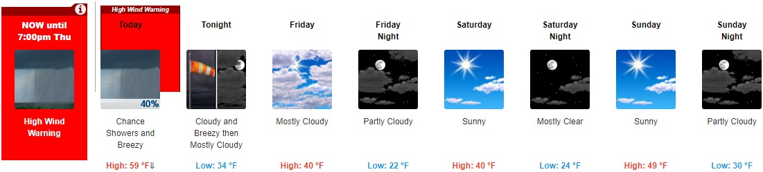
Today: A 40 percent chance of showers, mainly before 1pm. Cloudy, with a temperature falling to around 42 by 5pm. Breezy, with a southwest wind 23 to 25 mph, with gusts as high as 50 mph.
Tonight: Mostly cloudy, with a low around 34. Breezy, with a west wind 19 to 24 mph decreasing to 11 to 16 mph after midnight. Winds could gust as high as 40 mph.
Friday: Mostly cloudy, with a high near 40. Northwest wind around 10 mph.
Friday Night: Partly cloudy, with a low around 22. North wind 8 to 10 mph.
Saturday: Sunny, with a high near 40. North northeast wind 5 to 7 mph.
Saturday Night: Mostly clear, with a low around 24.
Sunday: Sunny, with a high near 49.
Sunday Night: Partly cloudy, with a low around 30.
Monday: Mostly sunny, with a high near 50.
Monday Night: Mostly cloudy, with a low around 32.
Tuesday: A 30 percent chance of showers. Mostly cloudy, with a high near 53.
Tuesday Night: Showers likely. Cloudy, with a low around 43. Chance of precipitation is 70%.
Wednesday: A 30 percent chance of showers. Mostly cloudy, with a high near 55.
THE UNITED STATES OF AMERICA 3-DAY OUTLOOK


SOURCE: NWS Indianapolis.
Follow NWS Indianapolis on Twitter @NWSIndianapolis for the latest Indianapolis area weather news.