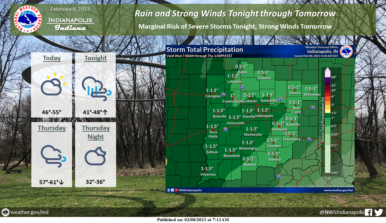
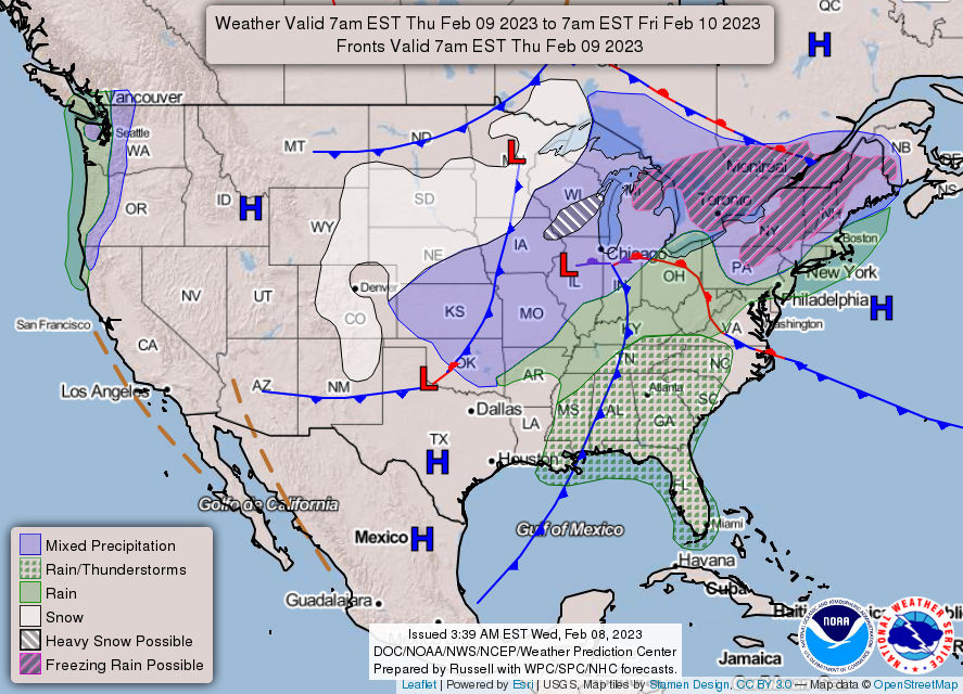
A storm system moving through the region will bring active weather tonight and tomorrow.
Temperatures will increase through the night tonight and drop through the day tomorrow.
Expect rain tonight with the potential for damaging winds embedded.
Strong non-thunderstorm winds will move in early tomorrow morning and last through the day Thursday.
STRONG WINDS THURSDAY
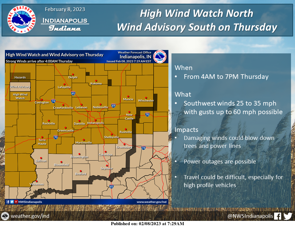
A High Wind Watch is in effect for the northern half of central Indiana on Thursday.
A Wind Advisory is in effect for southern parts of Central Indiana on Thursday.
Gusts of 50-55 mph are likely at times with up to 60 mph possible.
This could blow down trees and power lines.
Secure any loose outdoor items and use caution if traveling on Thursday.
HIGH WIND WATCH
National Weather Service Indianapolis, Indiana
3:42 AM EST Wednesday, February 8, 2023
Carroll County, Warren County, Tippecanoe County, Clinton County, Howard County, Fountain County, Montgomery County, Boone County, Tipton County, Hamilton County, Madison County, Delaware County, Randolph County, Vermillion County, Parke County, Putnam County, Hendricks County, Marion County, Hancock County, Henry County, Morgan County, Johnson County, Shelby County, and Rush County.
Including the cities of Delphi Indiana, Flora Indiana, Williamsport Indiana, West Lebanon Indiana, Lafayette Indiana, West Lafayette Indiana, Frankfort Indiana, Kokomo Indiana, Attica Indiana, Covington Indiana, Veedersburg Indiana, Crawfordsville Indiana, Lebanon Indiana, Zionsville Indiana, Tipton Indiana, Fishers Indiana, Carmel Indiana, Noblesville Indiana, Anderson Indiana, Muncie Indiana, Winchester Indiana, Union City Indiana, Farmland Indiana, Parker City Indiana, Clinton Indiana, Fairview Park Indiana, Rockville Indiana, Montezuma Indiana, Rosedale Indiana, Greencastle Indiana, Plainfield Indiana, Brownsburg Indiana, Danville Indiana, Indianapolis Indiana, Greenfield Indiana, New Castle Indiana, Martinsville Indiana, Mooresville Indiana, Greenwood Indiana, Franklin Indiana, Shelbyville Indiana, and Rushville Indiana.
HIGH WIND WATCH REMAINS IN EFFECT FROM THURSDAY MORNING THROUGH THURSDAY EVENING
WHAT…Southwest winds 25 to 35 mph with gusts up to 55 mph possible.
WHERE…Portions of central, east central, north central and west central Indiana.
WHEN…From Thursday morning through Thursday evening.
IMPACTS…Damaging winds could blow down trees and power lines. Widespread power outages are possible. Travel could be difficult, especially for high profile vehicles.
PRECAUTIONARY/PREPAREDNESS ACTIONS
Monitor the latest forecasts and warnings for updates on this situation. Fasten loose objects or shelter objects in a safe location prior to the onset of winds.
INDIANAPOLIS 7-DAY EXTENDED FORECAST
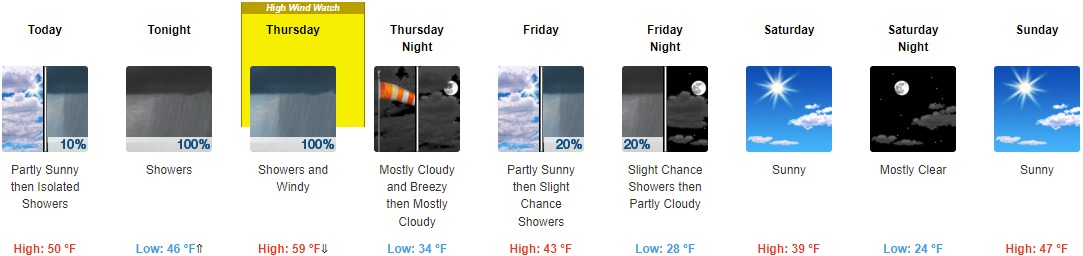
Today: Isolated showers after 5pm. Partly sunny, with a high near 50. Southeast wind 3 to 6 mph. Chance of precipitation is 10%.
Tonight: Showers, with thunderstorms also possible after 2am. Temperature falling to near 46 by 11pm, then rising to around 54 during the remainder of the night. East southeast wind 7 to 12 mph increasing to 13 to 18 mph after midnight. Winds could gust as high as 28 mph. Chance of precipitation is 100%. New rainfall amounts between three quarters and one inch possible.
Thursday: Showers and possibly a thunderstorm before 8am, then showers between 8am and 2pm. Temperature rising to near 59 by 8am, then falling to around 45 during the remainder of the day. Windy, with a south southeast wind 28 to 34 mph becoming west southwest in the afternoon. Winds could gust as high as 50 mph. Chance of precipitation is 100%. New precipitation amounts between a quarter and half of an inch possible.
Thursday Night: Mostly cloudy, with a low around 34. Breezy, with a west wind 21 to 26 mph decreasing to 11 to 16 mph after midnight. Winds could gust as high as 40 mph.
Friday: A 20 percent chance of showers after 2pm. Mostly cloudy, with a high near 43. West northwest wind 7 to 9 mph.
Friday Night: A 20 percent chance of showers before 8pm. Mostly cloudy, with a low around 28.
Saturday: Sunny, with a high near 39.
Saturday Night: Mostly clear, with a low around 24.
Sunday: Sunny, with a high near 47.
Sunday Night: Partly cloudy, with a low around 32.
Monday: Mostly cloudy, with a high near 52.
Monday Night: A 20 percent chance of showers. Mostly cloudy, with a low around 35.
Tuesday: A 50 percent chance of showers. Mostly cloudy, with a high near 54.
THE UNITED STATES OF AMERICA 3-DAY OUTLOOK

SOURCE: NWS Indianapolis.
Follow NWS Indianapolis on Twitter @NWSIndianapolis for the latest Indianapolis area weather news.