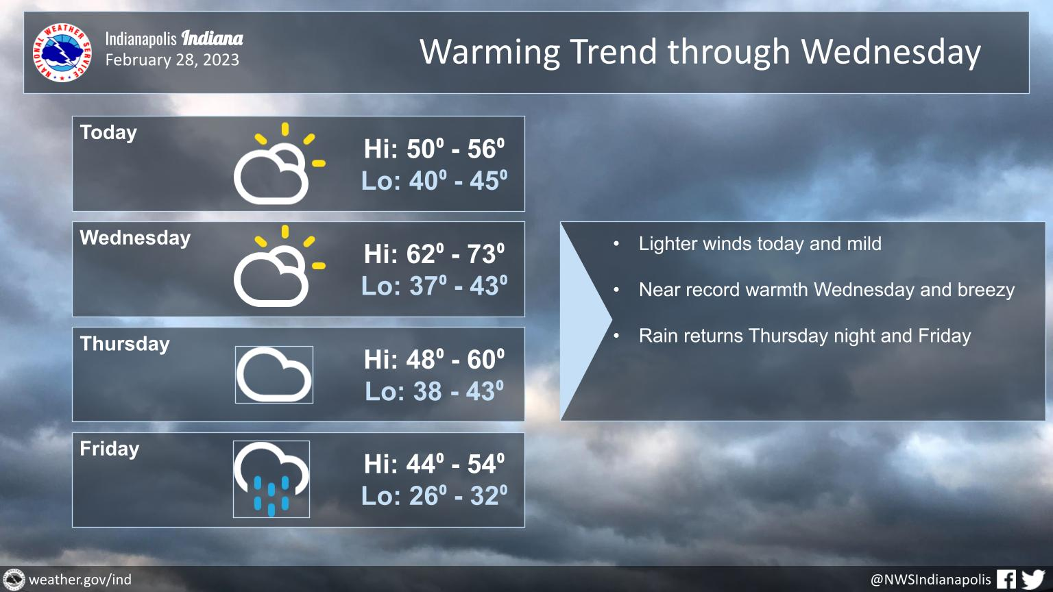
Less windy today and still mild. Clouds will decrease.
Wednesday will be warm and breezy with near record high temperatures possible.
Slight chance of rain Wednesday night, better chance Thursday night into Friday.
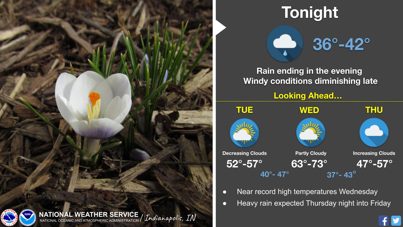
Rain and wind diminish this evening across Central Indiana.
Mild and dry Tuesday, then near record highs once again on Wednesday!
The chance for rain increases again Thursday night into Friday.
INDIANAPOLIS 7-DAY EXTENDED FORECAST
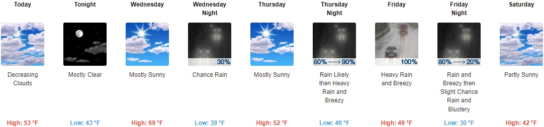
Today: Mostly cloudy, then gradually becoming sunny, with a high near 53. Northwest wind 5 to 13 mph becoming east northeast in the afternoon. Winds could gust as high as 18 mph.
Tonight: Mostly clear, with a low around 43. East wind 7 to 14 mph, with gusts as high as 22 mph.
Wednesday: Mostly sunny, with a high near 69. Southwest wind 10 to 13 mph, with gusts as high as 18 mph.
Wednesday Night: A chance of rain between 8pm and 2am. Mostly cloudy, then gradually becoming mostly clear, with a low around 39. West wind 9 to 11 mph becoming north after midnight. Chance of precipitation is 30%.
Thursday: Mostly sunny, with a high near 52. North wind around 9 mph.
Thursday Night: Rain, mainly after 8pm. The rain could be heavy at times. Low around 40. Breezy. Chance of precipitation is 90%. New precipitation amounts between three quarters and one inch possible.
Friday: Rain. The rain could be heavy at times. High near 49. Breezy. Chance of precipitation is 100%.
Friday Night: Rain, mainly before 8pm. Low around 30. Breezy. Chance of precipitation is 80%.
Saturday: Partly sunny, with a high near 42.
Saturday Night: Mostly cloudy, with a low around 29.
Sunday: Sunny, with a high near 47.
Sunday Night: Mostly clear, with a low around 33.
Monday: Mostly sunny, with a high near 58.
THE UNITED STATES OF AMERICA 3-DAY OUTLOOK


SOURCE: NWS Indianapolis.
Follow NWS Indianapolis on Twitter @NWSIndianapolis for the latest Indianapolis area weather news.