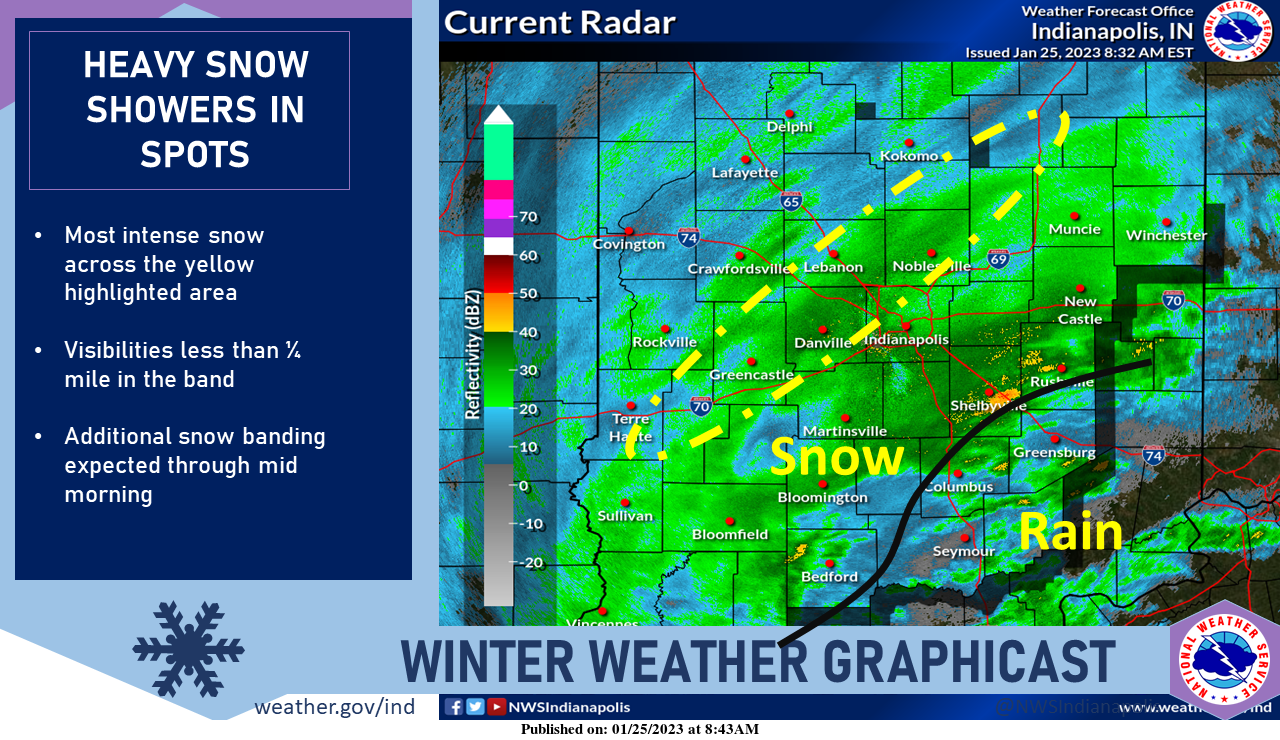
A band of heavy snow has set up north of I-70 and is slowly pivoting to the northwest.
Visibilities of less than 1/4 mile have been noted within the band with snowfall rates well over an inch per hour at times.
Further south the rain/snow line is approximately along the black line.
Lightning has been detected several times, so be sure to be listening for your chance to hear the thundersnow.
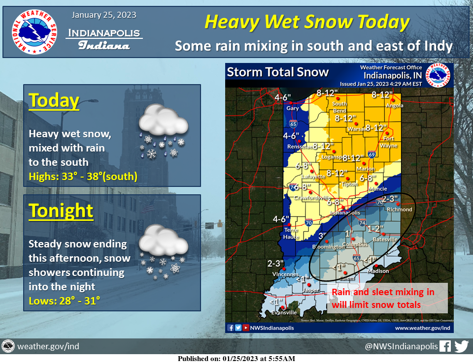
Heavy wet snow will continue to build into central Indiana with 1 to 3 inches already reported south of Indianapolis.
The most intense snowfall rates will occur between now and noon before the snow begins to taper off in the afternoon.
WINTER STORM WARNING
URGENT – WINTER WEATHER MESSAGE
National Weather Service Indianapolis, Indiana
9:34 AM EST Wednesday, January 25, 2023
Carroll County, Warren County, Tippecanoe County, Clinton County, Howard County, Fountain County, Montgomery County, Boone County, Tipton County, Hamilton County, Madison County, Delaware County, Randolph County, Vermillion County, Parke County, Putnam County, Hendricks County, Marion County, Hancock County, Henry County, Vigo County, and Clay County.
Including the cities of Delphi Indiana, Flora Indiana, Williamsport Indiana, West Lebanon Indiana, Lafayette Indiana, West Lafayette Indiana, Frankfort Indiana, Kokomo Indiana, Attica Indiana, Covington Indiana, Veedersburg Indiana, Crawfordsville Indiana, Lebanon Indiana, Zionsville Indiana, Tipton Indiana, Fishers Indiana, Carmel Indiana, Noblesville Indiana, Anderson Indiana, Muncie Indiana, Winchester Indiana, Union City Indiana, Farmland Indiana, Parker City Indiana, Clinton Indiana, Fairview Park Indiana, Rockville Indiana, Montezuma Indiana, Rosedale Indiana, Greencastle Indiana, Plainfield Indiana, Brownsburg Indiana, Danville Indiana, Indianapolis Indiana, Greenfield Indiana, New Castle Indiana, Terre Haute Indiana, and Brazil Indiana.
934 AM EST Wed Jan 25 2023
WINTER STORM WARNING REMAINS IN EFFECT UNTIL 7 PM EST THIS EVENING
- WHAT…Heavy snow. Total snow accumulations of 6 to 9 inches.
- WHERE…Portions of central, east central, north central, and west central Indiana.
- WHEN…Until 7 PM EST this evening.
- IMPACTS…Travel could be very difficult. The hazardous conditions could impact the morning or evening commute.
PRECAUTIONARY/PREPAREDNESS ACTIONS…
- If you must travel, keep an extra flashlight, food, and water in your vehicle in case of an emergency.
- The latest road conditions for Indiana can be obtained by calling 1-800-261-7623.
INDIANAPOLIS 7-DAY EXTENDED FORECAST
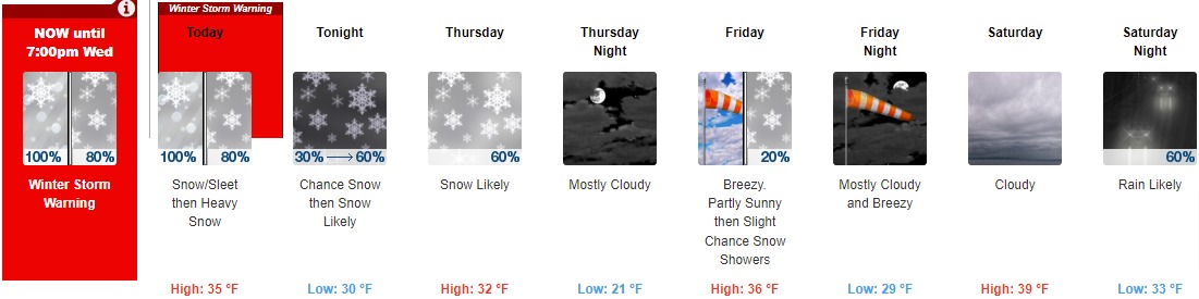
Today: Snow, possibly mixed with sleet, becomes snow after 11am. The snow could be heavy at times. High near 35. East-northeast wind 11 to 17 mph becoming northwest in the afternoon. Winds could gust as high as 26 mph. Chance of precipitation is 100%. Total daytime snow and sleet accumulation of 3 to 7 inches are possible.
Tonight: Snow likely, mainly after 5am. Cloudy, with a low of around 30. West wind 13 to 15 mph, with gusts as high as 22 mph. The chance of precipitation is 60%. New snow accumulation of less than a half inch is possible.
Thursday: Snow likely before 7am, then snow showers likely after 7am. Cloudy, with a high near 32. West wind 10 to 13 mph, with gusts as high as 20 mph. The chance of precipitation is 60%. New snow accumulation of around an inch is possible.
Thursday Night: Mostly cloudy, with a low of around 21. West wind 11 to 14 mph, with gusts as high as 21 mph.
Friday: A 20 percent chance of snow showers after 1pm. Mostly cloudy, with a high near 36. Breezy, with a south-southwest wind 13 to 22 mph, with gusts as high as 34 mph.
Friday Night: Mostly cloudy, with a low of around 29. Breezy.
Saturday: Cloudy, with a high near 39.
Saturday Night: Rain likely, mainly after 1am. Cloudy, with a low of around 33. The chance of precipitation is 60%.
Sunday: A 30 percent chance of snow. Cloudy, with a high near 36.
Sunday Night: A 20 percent chance of snow before 1am. Cloudy, with a low of around 25.
Monday: Mostly cloudy, with a high near 30.
Monday Night: A 20 percent chance of snow. Mostly cloudy, with a low around 21.
Tuesday: A 30 percent chance of snow. Cloudy, with a high near 32.
THE UNITED STATES OF AMERICA 3-DAY OUTLOOK


SOURCE: NWS Indianapolis.
Follow NWS Indianapolis on Twitter @NWSIndianapolis for the latest Indianapolis area weather news.