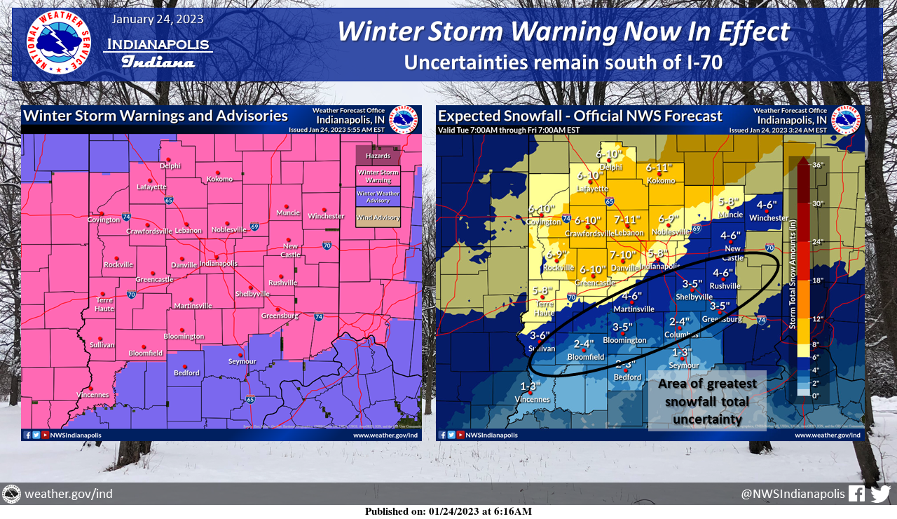
Winter Storm Warnings are now in effect across central Indiana.
Expect a broad area of 4 to 8 inches of snow with higher amounts north and west of Indianapolis.
Further south, rain and some dry air may limit amounts.
Precipitation should begin around midnight tonight.
WINTER STORM WARNING
URGENT – WINTER WEATHER MESSAGE
National Weather Service Indianapolis, Indiana
3:02 AM EST Tuesday, January 24, 2023
Carroll County, Warren County, Tippecanoe County, Clinton County, Howard County, Fountain County, Montgomery County, Boone County, Tipton County, Hamilton County, Madison County, Delaware County, Randolph County, Vermillion County, Parke County, Putnam County, Hendricks County, Marion County, Hancock County, Henry County, Vigo County, Clay County, Owen County, Morgan County, Johnson County, Shelby County, Rush County, Sullivan County, Greene County, Monroe County, Brown County, and Knox County
Including the cities of Delphi, Flora, Williamsport, West Lebanon, Lafayette, West Lafayette, Frankfort, Kokomo, Attica, Covington, Veedersburg, Crawfordsville, Lebanon, Zionsville, Tipton, Fishers, Carmel, Noblesville, Anderson, Muncie, Winchester, Union City, Farmland, Parker City, Clinton, Fairview Park, Rockville, Montezuma, Rosedale, Greencastle, Plainfield, Brownsburg, Danville, Indianapolis, Greenfield, New Castle, Terre Haute, Brazil, Spencer, Gosport, Martinsville, Mooresville, Greenwood, Franklin, Shelbyville, Rushville, Sullivan, Carlisle, Shelburn, Farmersburg, Linton, Bloomfield, Jasonville, Worthington, Bloomington, Nashville, and Vincennes
WINTER STORM WARNING IN EFFECT FROM 1 AM TO 7 PM EST WEDNESDAY
- WHAT…Heavy snow is expected. Total snow accumulations of 4 to 8 inches. Winds gusting as high as 35 mph.
- WHERE…Portions of central Indiana.
- WHEN…From 1 AM to 7 PM EST Wednesday.
- IMPACTS…Travel could be very difficult. The hazardous conditions could impact the morning or evening commute.
PRECAUTIONARY/PREPAREDNESS ACTIONS
- If you must travel, keep an extra flashlight, food, and water in your vehicle in case of an emergency.
- The latest road conditions for Indiana can be obtained by calling 1-800-261-7623.
SNOW TIMING
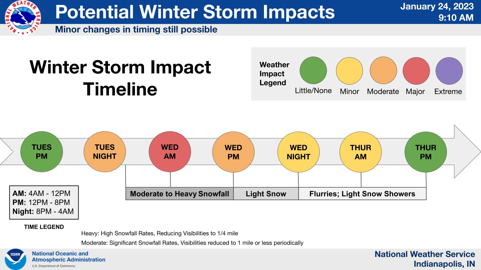
The impacts from the snowfall on Wednesday will be greatest from 4:00 AM Wednesday through 12:00 PM Wednesday.
Plan accordingly!
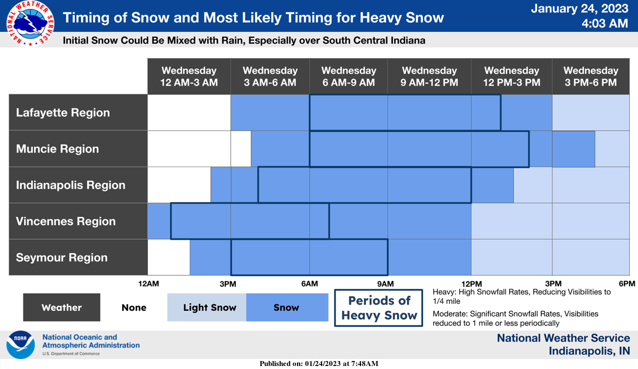
This is the current expectation for snowfall timing across central Indiana.
Initial snow could be mixed with rain but will transition to predominately snow within the 6 am to 9 am timeframe.
The heaviest snowfall should taper off in the early afternoon.
INDIANAPOLIS 7-DAY EXTENDED FORECAST
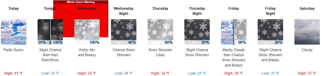
Today: Partly sunny, with a high near 41. Southwest wind 6 to 8 mph.
Tonight: Snow, possibly mixed with rain, becomes all snow after 4am. Low around 32. Light east wind increasing to 6 to 11 mph in the evening. Winds could gust as high as 18 mph. The chance of precipitation is 100%. New snow accumulation of 1 to 3 inches is possible.
Wednesday: Snow, possibly mixed with sleet before 7am, then snow, possibly mixed with rain and sleet between 7am and 4pm, then snow, possibly mixed with rain after 4pm. High near 35. Breezy, with an east wind of 16 to 21 mph becoming northeast 10 to 15 mph in the afternoon. Winds could gust as high as 30 mph. The chance of precipitation is 100%. New snow and sleet accumulation of 2 to 4 inches are possible.
Wednesday Night: A 40 percent chance of snow showers, mainly before 1am. Cloudy, with a low of around 30. West wind around 15 mph, with gusts as high as 22 mph.
Thursday: Snow showers likely, mainly after 1pm. Cloudy, with a high near 32. West wind 11 to 13 mph, with gusts as high as 18 mph. The chance of precipitation is 60%.
Thursday Night: A 20 percent chance of snow showers before 1am. Mostly cloudy, with a low around 21.
Friday: A 30 percent chance of snow showers after 1pm. Mostly cloudy, with a high near 36. Breezy.
Friday Night: A 20 percent chance of snow showers before 1am. Cloudy, with a low of around 31. Breezy.
Saturday: Cloudy, with a high near 37.
Saturday Night: A chance of rain and snow showers before 1am, then a chance of snow showers. Cloudy, with a low of around 29. The chance of precipitation is 40%.
Sunday: A chance of rain and snow showers. Cloudy, with a high near 35. The chance of precipitation is 50%.
Sunday Night: A chance of rain and snow showers. Cloudy, with a low of around 20. The chance of precipitation is 30%.
Monday: Mostly cloudy, with a high near 27.
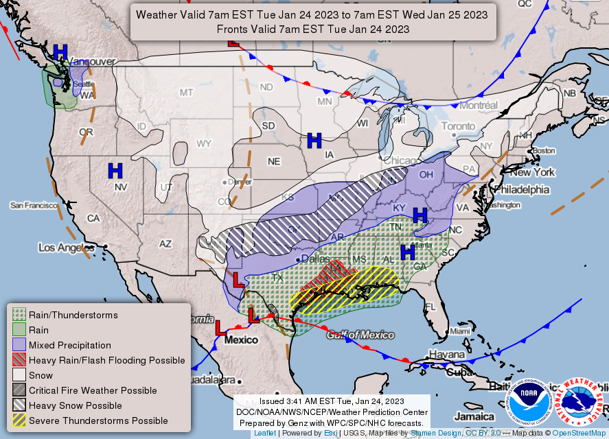
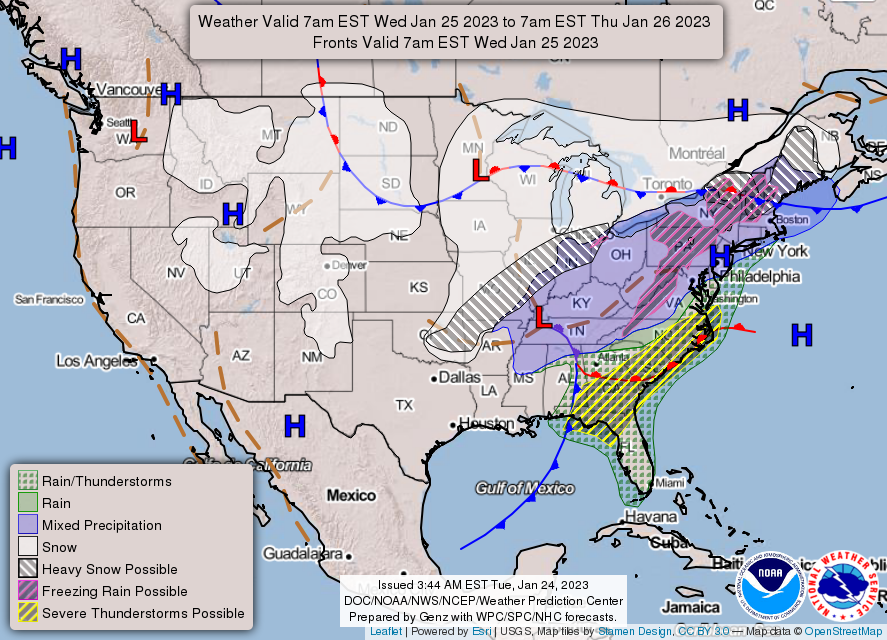
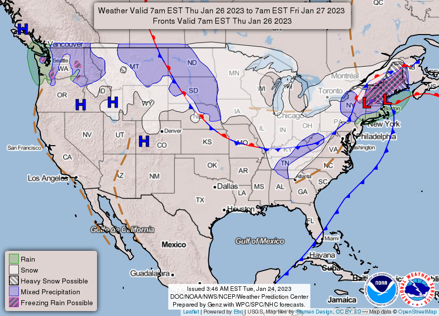
THE UNITED STATES OF AMERICA 3-DAY OUTLOOK
SOURCE: NWS Indianapolis.
Follow NWS Indianapolis on Twitter @NWSIndianapolis for the latest Indianapolis area weather news.