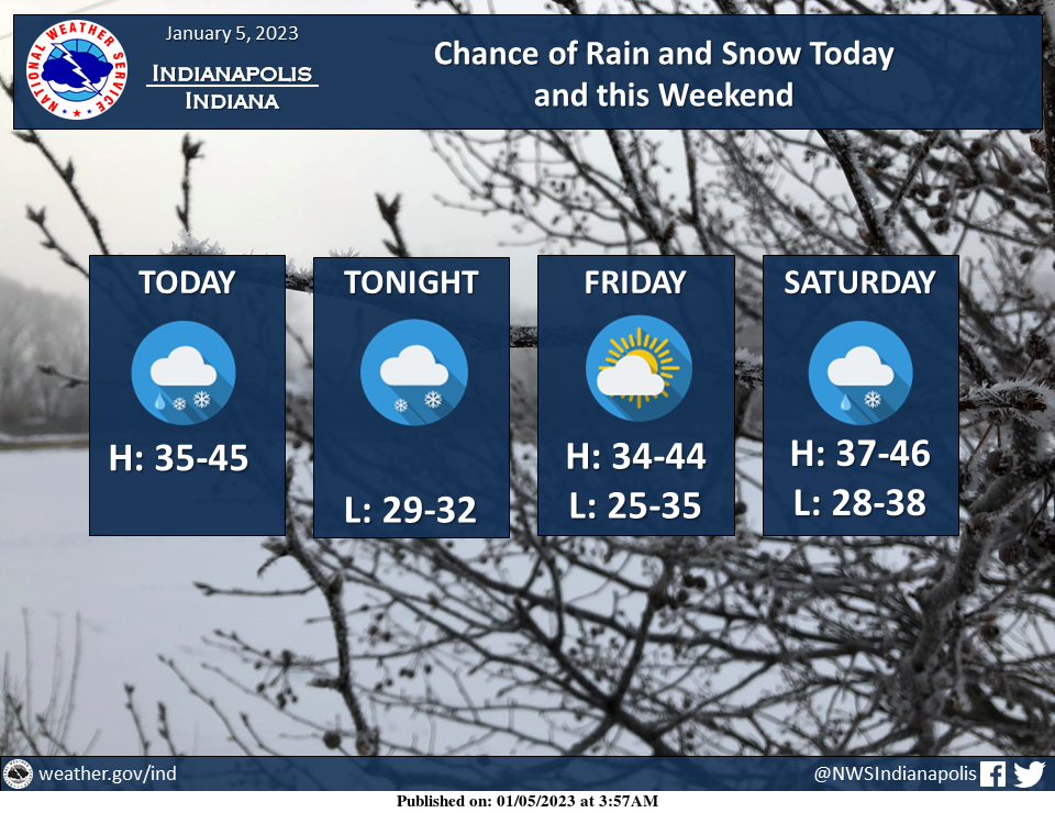
There is a chance of a mix of rain and snow mix today and a chance of snow tonight with light snow accumulation of half an inch or less possible north.
Additional rain and snow chances are also in store for the weekend.
INDIANAPOLIS 7-DAY EXTENDED FORECAST
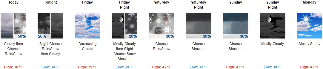
Today: A slight chance of rain and snow before 2pm, then a chance of rain between 2pm and 4pm, then a chance of rain and snow after 4pm. Cloudy, with a high near 38. Southwest wind 9 to 13 mph, with gusts as high as 21 mph. The chance of precipitation is 50%. New precipitation amounts of less than a tenth of an inch possible.
Tonight: A slight chance of rain and snow before 7pm. Cloudy, with a low of around 30. West wind 9 to 11 mph, with gusts as high as 21 mph. The chance of precipitation is 20%.
Friday: Cloudy, then gradually becoming mostly sunny, with a high near 39. West wind 6 to 8 mph.
Friday Night: A 20 percent chance of snow showers after 1am. Mostly cloudy, with a low of around 29. Light west-southwest wind.
Saturday: A chance of snow showers before 10am, then a chance of rain and snow showers between 10am and 1pm, then a chance of rain showers after 1pm. Partly sunny, with a high near 42. Calm wind becoming east around 5 mph in the afternoon. The chance of precipitation is 30%.
Saturday Night: A 30 percent chance of showers, mainly after 1am. Mostly cloudy, with a low around 32.
Sunday: A 30 percent chance of showers, mainly before 1pm. Mostly cloudy, with a high near 43.
Sunday Night: Mostly cloudy, with a low of around 30.
Monday: Mostly sunny, with a high near 45.
Monday Night: Partly cloudy, with a low around 35.
Tuesday: A 20 percent chance of showers. Mostly cloudy, with a high near 46.
Tuesday Night: Mostly cloudy, with a low of around 32.
Wednesday: Partly sunny, with a high near 41.
THE UNITED STATES OF AMERICA 3-DAY OUTLOOK


SOURCE: NWS Indianapolis.
Follow NWS Indianapolis on Twitter @NWSIndianapolis for the latest Indianapolis area weather news.