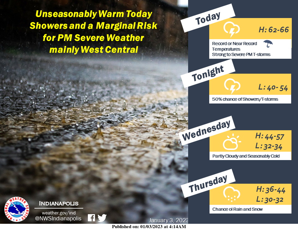
Look for Record or Near Record High Temperatures Today in the 60s along with widespread showers and thunderstorms.
A few of these could be strong or severe this afternoon and early evening over mainly the Wabash Valley and parts of south-central Indiana.
Damaging winds, large hail, brief heavy rain, and cloud-to-ground lightning are all possible.
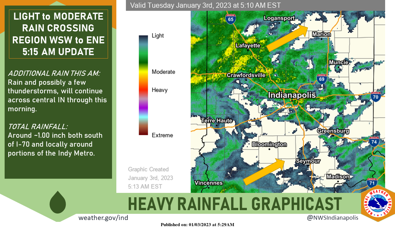
Periods of rain, moderate to perhaps briefly heavy at times, will continue through this morning before a lull in precipitation this afternoon.
Isolated thunderstorms are possible.
Storm totals locally over 1.00″ are expected around the Indy metro and south of I-70.
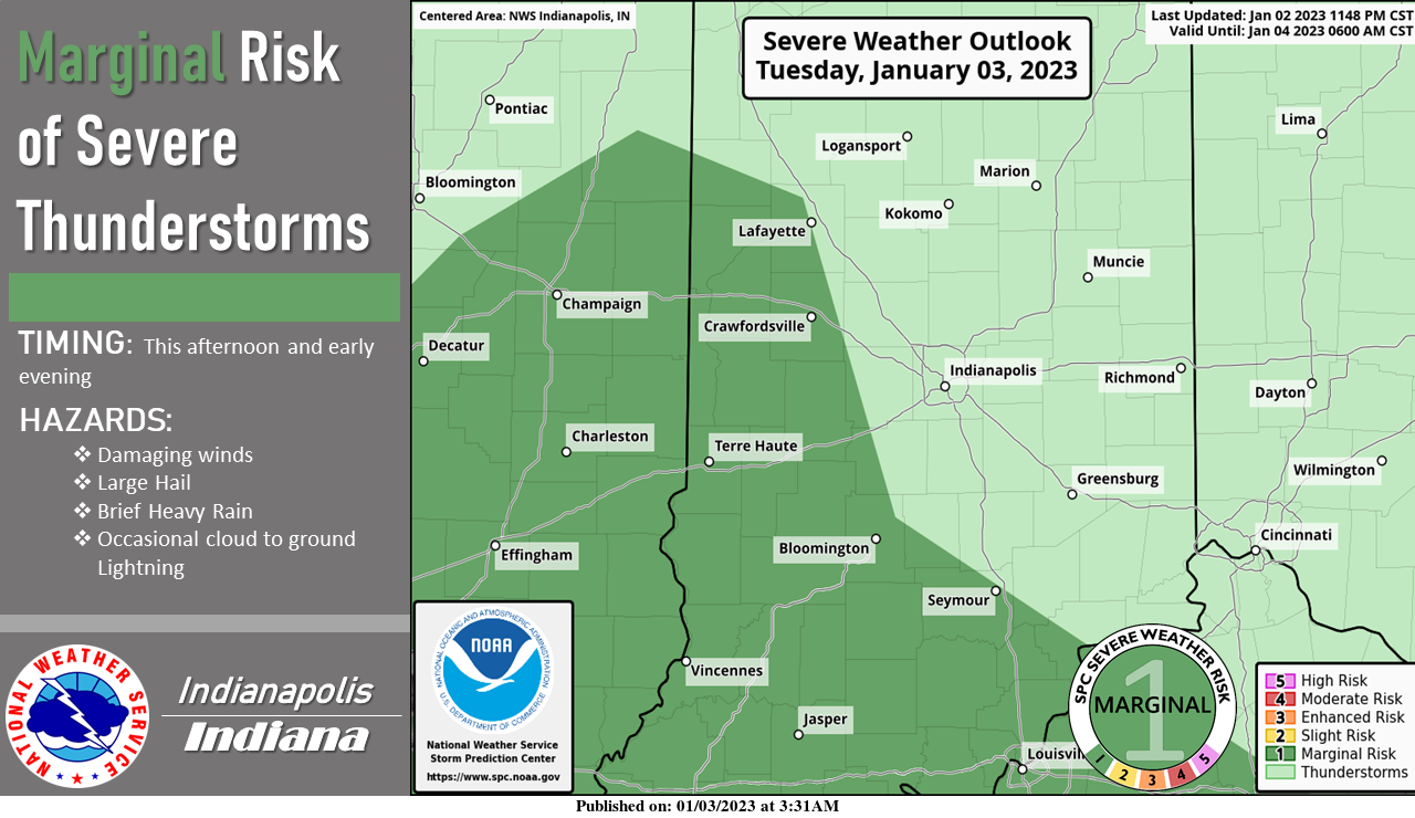
Strong to marginally severe thunderstorms will be possible over mainly the Wabash Valley and parts of south-central Indiana this afternoon and early evening.
Monitor news sources for updates and possible severe weather watches and warnings today.
INDIANAPOLIS 7-DAY EXTENDED FORECAST
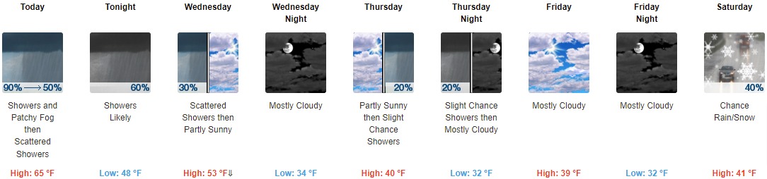
Today: Showers and thunderstorms before 2pm, then isolated showers between 2pm and 5pm, then isolated showers and thunderstorms after 5pm. Patchy fog before noon. High near 65. South southwest wind 7 to 13 mph, with gusts as high as 28 mph. The chance of precipitation is 90%. New rainfall amounts between a tenth and a quarter of an inch, except higher amounts possible in thunderstorms.
Tonight: Isolated showers and thunderstorms before 8pm, then showers likely and possibly a thunderstorm between 8pm and 2am, then scattered showers and thunderstorms after 2am. Mostly cloudy, with a low of around 48. South southwest wind 8 to 11 mph, with gusts as high as 21 mph. The chance of precipitation is 60%. New rainfall amounts to less than a tenth of an inch, except higher amounts possible in thunderstorms.
Wednesday: Scattered showers before 8am. Cloudy, then gradually becoming mostly sunny, with a temperature falling to around 46 by 5pm. West southwest wind 5 to 11 mph, with gusts as high as 20 mph. The chance of precipitation is 30%.
Wednesday Night: Mostly cloudy, with a low of around 34. West southwest wind 6 to 10 mph, with gusts as high as 18 mph.
Thursday: A 20 percent chance of showers after 2pm. Mostly cloudy, with a high near 40. Southwest wind 6 to 10 mph, with gusts as high as 18 mph.
Thursday Night: A 20 percent chance of showers before 8pm. Cloudy, with a low of around 32.
Friday: Mostly cloudy, with a high near 39.
Friday Night: Mostly cloudy, with a low of around 32.
Saturday: A chance of rain and snow showers between 8am and 2pm, then a chance of rain showers after 2pm. Mostly cloudy, with a high near 41. The chance of precipitation is 40%.
Saturday Night: A chance of rain showers before 2am, then a slight chance of rain showers, snow showers, and freezing rain. Mostly cloudy, with a low of around 31. The chance of precipitation is 40%.
Sunday: A slight chance of rain showers, snow showers, and freezing rain. Mostly cloudy, with a high near 40. The chance of precipitation is 20%.
Sunday Night: Mostly cloudy, with a low of around 29.
Monday: Mostly sunny, with a high near 41.
THE UNITED STATES OF AMERICA 3-DAY OUTLOOK


SOURCE: NWS Indianapolis.
Follow NWS Indianapolis on Twitter @NWSIndianapolis for the latest Indianapolis area weather news.