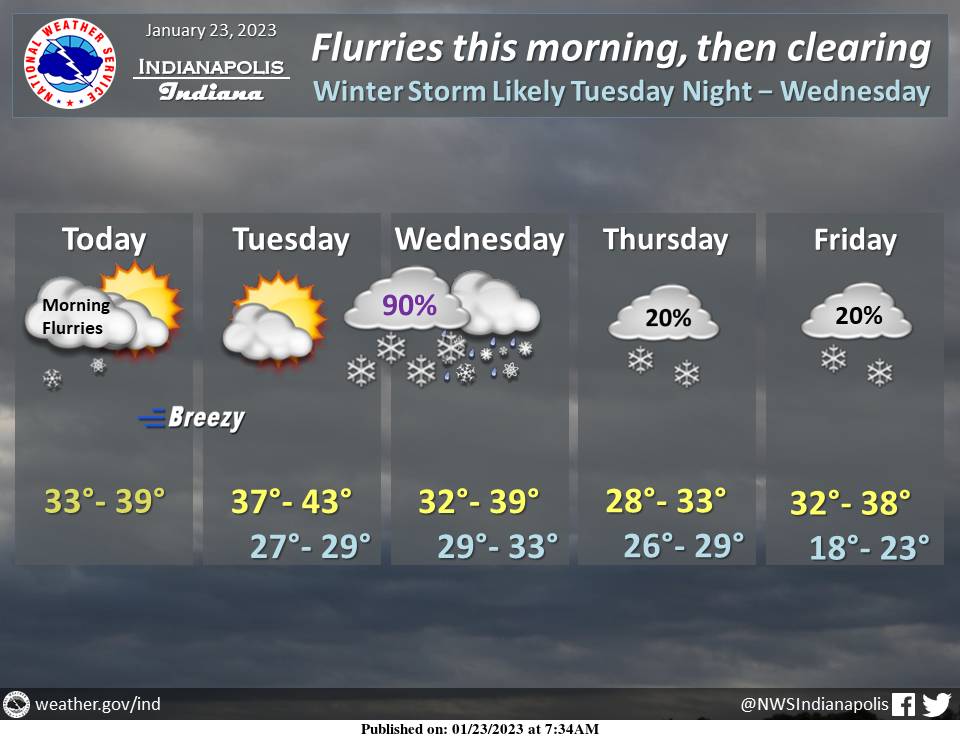
Morning flurries should give way to partial clearing this afternoon.
Clouds return quickly on Tuesday, however, ahead of a potentially significant winter storm.
Rain and snow are likely on Wednesday with lingering snow showers through Friday. #INwx #nwsind
WINTER STORM WATCH
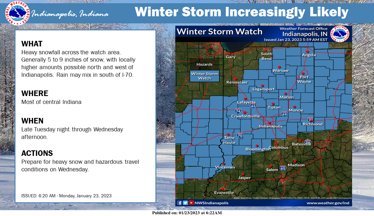
A Winter Storm Watch is now in effect from late Tuesday night into Wednesday afternoon.
Heavy snowfall is the primary concern, with 5 to 9 inches possible.
Some mixing with rain is possible south of I-70 which may limit accumulations a bit.
URGENT WINTER WEATHER MESSAGE
National Weather Service Indianapolis, Indiana
940 AM EST Mon Jan 23, 2023
Carroll County, Warren County, Tippecanoe County, Clinton County, Howard County, Fountain County, Montgomery County, Boone County, Tipton County, Hamilton County, Madison County, Delaware County, Randolph County, Vermillion County, Parke County, Putnam County, Hendricks County, Marion County, Hancock County, Henry County, Vigo County, Clay County, Owen County, Morgan County, Johnson County, Shelby County, Rush County, Sullivan County, Greene County, Monroe County, Brown County, and Knox County
Including the cities of Delphi, Flora, Williamsport, West Lebanon, Lafayette, West Lafayette, Frankfort, Kokomo, Attica, Covington, Veedersburg, Crawfordsville, Lebanon, Zionsville, Tipton, Fishers, Carmel, Noblesville, Anderson, Muncie, Winchester, Union City, Farmland, Parker City, Clinton, Fairview Park, Rockville, Montezuma, Rosedale, Greencastle, Plainfield, Brownsburg, Danville, Indianapolis, Greenfield, New Castle, Terre Haute, Brazil, Spencer, Gosport, Martinsville, Mooresville, Greenwood, Franklin, Shelbyville, Rushville, Sullivan, Carlisle, Shelburn, Farmersburg, Linton, Bloomfield, Jasonville, Worthington, Bloomington, Nashville, and Vincennes
940 AM EST Mon Jan 23 2023
…WINTER STORM WATCH REMAINS IN EFFECT FROM LATE TUESDAY NIGHT THROUGH WEDNESDAY AFTERNOON…
* WHAT…Heavy snow is possible. Total snow accumulations of 2 to 8 inches are possible.
* WHERE…Portions of central, east-central, north-central, south-central, southwest, and west-central Indiana.
* WHEN…From late Tuesday night through Wednesday afternoon.
* IMPACTS…Travel could be very difficult. The hazardous conditions could impact the morning commute.
PRECAUTIONARY/PREPAREDNESS ACTIONS…
Monitor the latest forecasts for updates on this situation.
INDIANAPOLIS 7-DAY EXTENDED FORECAST
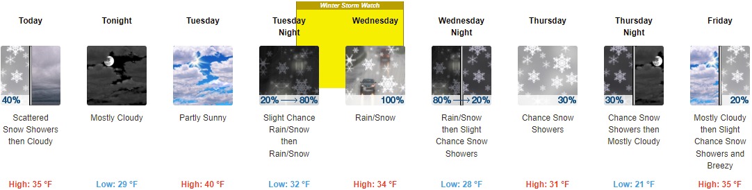
Today: Flurries with scattered snow showers before 11am, then flurries between 11am and noon. Cloudy, with a high near 35. West wind around 11 mph. The chance of precipitation is 40%.
Tonight: Mostly cloudy, with a low of around 29. West southwest wind 13 to 16 mph, with gusts as high as 25 mph.
Tuesday: Partly sunny, with a high near 40. Southwest wind 6 to 11 mph.
Tuesday Night: A slight chance of rain showers before 11pm, then snow showers, possibly mixed with rain. Low around 32. Light south-southeast wind becoming east 5 to 10 mph in the evening. The chance of precipitation is 80%. New precipitation amounts between a tenth and a quarter of an inch possible.
Wednesday: Snow showers, possibly mixed with rain. The snow could be heavy at times. High near 34. East wind 10 to 17 mph becoming north in the afternoon. Winds could gust as high as 26 mph. The chance of precipitation is 100%. New precipitation amounts between a half and three-quarters of an inch possible.
Wednesday Night: Snow showers, possibly mixed with rain before 8pm, then a slight chance of snow showers. Low around 28. The chance of precipitation is 80%. New precipitation amounts to less than a tenth of an inch possible.
Thursday: A 30 percent chance of snow showers, mainly after 2pm. Cloudy, with a high near 31.
Thursday Night: A 30 percent chance of snow showers before 8pm. Mostly cloudy, with a low around 21.
Friday: A 20 percent chance of snow showers after 2pm. Mostly cloudy, with a high near 35. Breezy.
Friday Night: A 20 percent chance of snow showers before 2am. Cloudy, with a low of around 29.
Saturday: Mostly cloudy, with a high near 37.
Saturday Night: A 30 percent chance of showers. Cloudy, with a low around 28.
Sunday: A 50 percent chance of showers. Cloudy, with a high near 37.
THE UNITED STATES OF AMERICA 3-DAY OUTLOOK


SOURCE: NWS Indianapolis.
Follow NWS Indianapolis on Twitter @NWSIndianapolis for the latest Indianapolis area weather news.