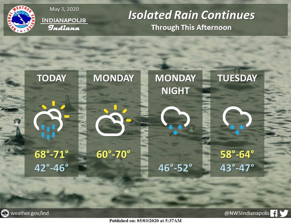
Thunderstorms should move out of central Indiana by midday with isolated rain continuing into the afternoon.
Rain is expected to return to the area Monday night.
Via NWS Indianapolis. Follow them on Twitter @NWSIndianapolis for the latest Indianapolis area weather news.
AROUND TWITTER
High in Indy Saturday (5/2): 82°
Forecast High Next Saturday (5/9): Near 50°
Freeze Warnings likely Mother’s Day weekend with growing possibility of lows in 20s/lower 30s.
Only 17 years on record in Indy where last <=32° temp of season occurred in May. (1/2) #13Weather #INwx pic.twitter.com/kUOxz1uCKK
— Sean Ash (@SeanAshWX) May 3, 2020
Coldest May temp on record in Indy is 28° (May 10, 1966)
Latest <=32° temp in Indy: 31° on May 27, 1961
Latest date of measurable snow in Indy: May 9, 1923
With or without records…Mother’s Day weekend looks to be nearly 20° colder than average (2/2) #13Weather #INwx
— Sean Ash (@SeanAshWX) May 3, 2020
My neighbor’s house was struck by lightening last night. Everyone made it out safely- thank God. #INWX @marcusbailey @MetTaraHastings @WISH_TV pic.twitter.com/WwxqXiJkQf
— Phil Sanchez (@PhilSanchezTV) May 3, 2020
Amber’s #Doodlecast >> It is National Paranormal Day 👻! Spotty t-showers around at times. Severe weather is not anticipated. Decreasing clouds late! High: 71° @fox59 @thewxauthority #INwx #FOX59morning #sketchforecast pic.twitter.com/F0NMkO7yDz
— Amber Hardwick (@AHardwickWx) May 3, 2020
We still can't rule out a couple of showers, but most of the day will be dry. It's cooler, but seasonable for early May. #INwx pic.twitter.com/6EHw3l03gz
— Kyle Mounce (@kylemounce) May 3, 2020
UNSEASONABLY COOL STRETCH AHEAD…
Highs drop from near 70 today to the upper 50s next week. The cooler trend in the forecast. #13Weather #INwx @wthrcom | https://t.co/pokma2Xt8r pic.twitter.com/OyStlVIiuj— Lindsey Monroe (@LindseyWTHR13) May 3, 2020
24 Hour Rain Totals >> The highest totals fell just south of Indy.. along I-70 west of the city…and I-74 east of downtown. You can see the path of the stronger cells from last night on our radar estimate map! @FOX59 @theWXauthority #INwx #FOX59morning pic.twitter.com/TR0hBrVuZl
— Amber Hardwick (@AHardwickWx) May 3, 2020
Quite the lightning show over Shelby, Johnson and Rush counties right now. Hail, heavy rain, lightning are expected with this complex of storms as it travels E around 50 MPH. #INwx @FOX59 @theWXauthority pic.twitter.com/pe4n3MJ4PW
— Amber Hardwick (@AHardwickWx) May 3, 2020
Storm clusters still moving through central Indiana producing heavy rain and lightning. Hail threat dwindling as storms weaken. #13Weather #INwx @wthrcom pic.twitter.com/SUbtwivnl7
— Lindsey Monroe (@LindseyWTHR13) May 3, 2020
….stillllllll going #woke #13weather #INwx pic.twitter.com/CQZDXttLUf
— Sean Ash (@SeanAshWX) May 3, 2020
GUARDIAN RADAR (4:10 AM) >> Another storm to watch… Strong storm producing torrential downpours…hail possible. Getting ready to move into northern Vigo County. Southern Park, Vermillion counties also in path. Tracking E & 45 MPH. #INwx @FOX59 @theWXauthority pic.twitter.com/2ZsnqWQsjo
— Amber Hardwick (@AHardwickWx) May 3, 2020