• Skip to primary navigation
  • Skip to main content
  • Skip to primary sidebar
  • Naptown Buzz
    • About Naptown Buzz
      • Advertising
      • Media Coverage
        • Podcast Requests
        • Submissions
    • Contact Naptown Buzz
    • Event Schedule
    • Mailing List
    • Newsletter Archive
  • Photos
  • Videos
  • The Buzz
  • Events
  • Biz Directory
  • Guides
    • 2023 Holiday
    • Cocktails

Naptown Buzz

Your source for all things Indy™

  • Indy News
    • Crime
    • Public Works
    • Weather
  • Community
    • Community Roundups
    • Festivals
    • Job Board
    • Gen Con
  • Indiana News
    • Crime
    • Education
    • Indiana State Fair
  • Nation & World
  • Business
  • Arts & Entertainment
    • Arts
    • Music & Nightlife
  • Living
    • Food & Drink
      • Adult Beverages
    • Games
    • Technology
    • Travel
  • Sports
    • Racing
      • INDYCAR
      • NASCAR
      • Lucas Oil Raceway
      • NHRA
      • SRX
    • ECHL
      • Indy Fuel
    • MiLB
      • Indianapolis Indians
You are here: Home / Greater Indianapolis / Indianapolis Weather Forecast for April 8, 2020 ~ #INwx

Indianapolis Weather Forecast for April 8, 2020 ~ #INwx

April 8, 2020 by Naptown Buzz

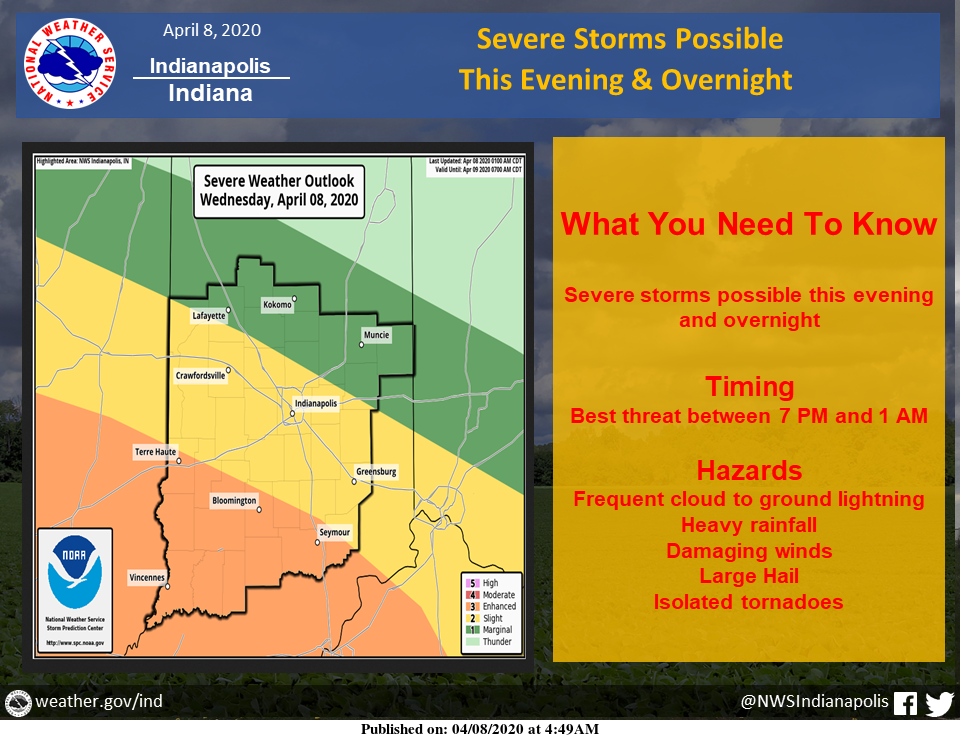
Severe storms possible this evening and overnight ahead of a cold front.

Damaging winds, large hail, isolated tornadoes are all possible. Locally heavy rain and frequent lightning are possible with any storm.

The primary window for severe weather is 7:00 PM to 1:00 AM EDT.

During the day today look for partly cloudy skies and warm temperatures.

Much colder air moves in for Thursday.

Via NWS Indianapolis. Follow them on Twitter @NWSIndianapolis for the latest Indianapolis area weather news.

AROUND TWITTER

Quiet much of the day before more potentially severe storms this evening/early tonight. Much colder air arrives Thursday & cold enough for mixed showers by Thursday evening…along with some thunder #INwx pic.twitter.com/30UUPUuW3I

— Sean Ash (@SeanAshWX) April 8, 2020

Amber’s #Doodlecast >> Another great day filled with ☀️ sunshine! Warm too! High: 77° … Heads up this evening/ tonight’ Some storms may become 💪 strong…Gusty wind/hail threat! @fox59 @thewxauthority #INwx #sketchforecast pic.twitter.com/p2270piW5u

— Amber Hardwick (@AHardwickWx) April 8, 2020

We're half way through the week! Here's how the day is shaping up. #INwx pic.twitter.com/wHff3lWCEl

— Kyle Mounce (@kylemounce) April 8, 2020

It’s going to be another beautiful day with sunshine and highs near 80! But that will all change when storms arrive tonight and a cold front sweeps across the state. There’s a threat of strong winds and hail between 8 p.m. and 2 a.m. https://t.co/tBmsKRMxKi #INwx #FOX59Morning

— FOX59 News (@FOX59) April 8, 2020

https://twitter.com/StarDerryWX/status/1247825390133018625

Yesterday we hit 79°! Not quite as warm today but still a good 15° above normal! Highs will hit the mid 70s with possible storms mid evening! Should also get some sunshine today! @WISH_TV #Indy #INwx pic.twitter.com/mh77goJTe4

— Stephanie Mead (@stephmeadwx) April 8, 2020

https://twitter.com/StarDerryWX/status/1247819803043213312

Spread the love

ADVERTISING NOTICE

Some posts and pages on Naptown Buzz contain affiliate links for which we receive an affiliate commission.

Additionally, you can support Naptown Buzz by making your everyday Amazon purchases through our Amazon link.


Filed Under: Greater Indianapolis, Weather Tagged With: Indiana Weather, Indianapolis Weather, Indy Weather, INwx, National Weather Service, NWS Indianapolis, Weather

Primary Sidebar

Subscribe

Contact Naptown Buzz

Naptown Buzz Logo
Buzzline: 317-891-4627 or email

RSS Twitter Facebook Flickr YouTube Podcast Foursquare Email Naptown Buzz

Copyright © 2010-2024 Naptown Buzz LLC • Designed by Watershed Studio LLC