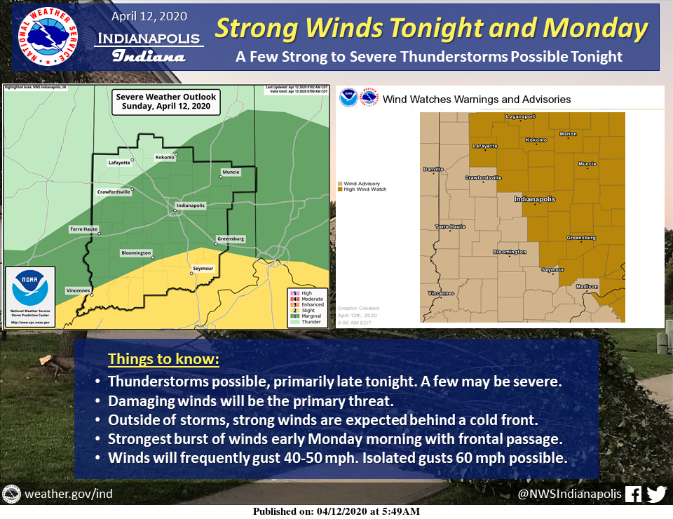
Active weather is expected to end the weekend and start the workweek across central Indiana.
Showers and thunderstorms will be possible, especially late tonight, across central Indiana. A few storms late tonight may be severe, with damaging winds the primary threat.
Outside of thunderstorms, strong winds are also expected behind a cold front sweeping through the area. The strongest burst of winds will likely be early Monday morning with the passage of this front, but strong winds will continue into Monday. Frequent gusts of 40 to 50 MPH are expected, with isolated gusts up to 60 MPH possible.
Via NWS Indianapolis. Follow them on Twitter @NWSIndianapolis for the latest Indianapolis area weather news.
AROUND TWITTER
SEVERE THREAT OVERNIGHT, 50+ MPH WINDS TOMORROW…
There will be lots of dry hours today with a few strong storms overnight. Non-storm wind damage possible through tomorrow morning. Plan ahead #INwx @WTHRcom | https://t.co/s9L69BoA4K pic.twitter.com/iYc7kphGEr— Lindsey Monroe (@LindseyWTHR13) April 12, 2020
Stay weather aware late tonight (after Midnight) for a few strong storms south of I-70. Damaging wind the primary concern #INwx https://t.co/7tyk2f8qLK @wish_tv pic.twitter.com/i1qjLB2E38
— Marcus Bailey (@marcusbailey) April 12, 2020
Widely scattered showers possible today. Light rain is already moving into our southwestern counties @ this hour. Temps will still be mild with a high of 61°! Storm chances rise overnight as a potent system travels over IN! A few gusty t-storms possible! @FOX59 @theWXauthority pic.twitter.com/pL029yecl1
— Amber Hardwick (@AHardwickWx) April 12, 2020
ALERT: Active weather expected overnight into Monday. Strong to severe storms are possible between 2am and 8am Monday. Gusty winds are the main threat. Storms followed by more strong winds Monday. Gusts could top 50 mph for some. #INwx pic.twitter.com/XuZ9wxPXzD
— Kyle Mounce (@kylemounce) April 12, 2020
Happy Easter! Splash-and-dashers on radar this morning. Severe storms possible later (after midnight) tonight with strong (50+ mph) non-thunderstorm gusts likely midday Monday #INwx pic.twitter.com/005fgvaGvc
— Sean Ash (@SeanAshWX) April 12, 2020
Good morning and happy Easter! Nice colors to start off the day – showers and storms return this afternoon and evening. @wish_tv#INwx https://t.co/7tyk2f8qLK pic.twitter.com/LA1RHOIws9
— Marcus Bailey (@marcusbailey) April 12, 2020
STRONG WINDS MONDAY >> High Wind Watch & Wind Advisory issued across central Indiana for Monday. A strengthening low pressure system will track over Indiana. The pressure gradient will tighten and gusty winds will be possible, especially MON AM! #INwx @FOX59 @theWXauthority pic.twitter.com/ZXg4TunVaw
— Amber Hardwick (@AHardwickWx) April 12, 2020
Amber’s #Doodlecast >> Happy Easter!🐰Widely scattered showers 🌧 are in the forecast for today. It’s going to be mild as we head into the afternoon with a high of 61°! Storm ⛈ chances rise overnight… Some could become strong and produce gusty winds. @fox59 @thewxauthority pic.twitter.com/zO7NCOeWfn
— Amber Hardwick (@AHardwickWx) April 12, 2020